Biyangdo — A Half-Day Trek Around the Island Korea Once Watched Rise
A 15-Minute Ferry From Hyeopjae and a 3.5-km Loop Past Hornitos, a Crater Lake, and a 1955 Lighthouse
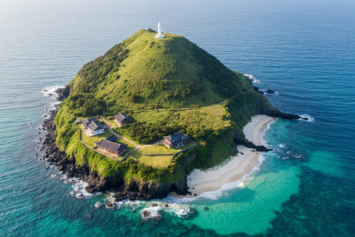
Biyangdo is a 0.59 km² volcanic island off the west coast of Jeju, reachable by 15-minute ferry from Hyeopjae or Hallim Port. The 3.5 km (2.2 mile) loop takes 90 minutes to 2 hours on foot; adding the 114 m Biyang-bong lighthouse summit brings the visit to about 3 hours. Inside the perimeter walk sit a brackish crater lake, the Elephant Rock formation, and Korea's best-preserved hornito field (Natural Monument No. 439). About 150 people live on the island, mostly working in fisheries. From Hyeopjae Port the drive to Galchibada in Aewol takes 15 minutes east along the coastal road.
Stand on the Hyeopjae sand and a small island sits centred in the middle of your field of view, almost close enough to wade to. The crossing takes fifteen minutes. A small ferry from Hyeopjae or Hallim port cuts across emerald shallows toward an outline that grows steadily larger; partway across, the smell of the open sea reaches the deck and the basalt shoreline resolves into focus. The island's name, in Hanja, is 飛揚島 — "the island that flew up." A line in the Goryeosa, the official chronicle of the Goryeo dynasty, records that in <strong>1002 CE</strong> "four mountains rose from the sea on Tamna" — and a portion of Jeju local historiography reads one of those mountains as Biyangdo. Geologists today place the actual formation closer to <strong>27,000 years ago</strong>, but the longer history of someone recording a rising in this place still matters when you put your foot on it.
Fifteen Minutes Across, and the Pace Drops
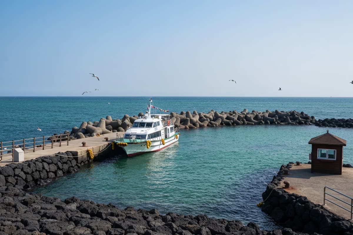
Ferry departures shift by season; in standard months, roughly four to five round trips run daily between Hyeopjae or Hallim and Biyangdo. Fifteen minutes is short, but the shoreline rewrites itself completely in that window. White sand and palm rows leave the visual field; black basalt and a working fishing harbour take their place.
The moment a passenger steps onto the Biyangdo pier, the walking pace drops by about half. The island makes the adjustment for you. <strong>0.59 km² (0.23 sq mi)</strong> of surface area, a 3.5 km (2.2 mile) perimeter — a 90-minute to two-hour loop at an honest adult pace, with no reason to hurry. For Western visitors who have done the perimeter walk on Sark in the Channel Islands or Aran Mór off Galway, the scale and the sea-as-boundary feeling are familiar; the volcanic substrate is what makes this one different.
Off the pier, a left turn takes you counter-clockwise past the village and the hornito field; a right turn takes you clockwise past Elephant Rock and the lighthouse first. Either direction closes the loop in the same place. Morning arrivals usually take the counter-clockwise direction to keep the sun at the back.
The 1002 CE Chronicle Entry
A short passage in the Goryeosa, dated to King Mokjong's fifth regnal year — <strong>1002 CE</strong> — records: "On Tamna, four mountains rose from the sea, and flames went up from them." Tamna was the old name for Jeju, and a strand of local historiography reads one of those four mountains as Biyangdo. The "youngest-looking volcanic island in Korea" tag travels with the island for this reason.
Academic geology disagrees with the direct mapping. Recent volcanological work places the actual formation of Biyangdo closer to <strong>27,000 years before present</strong>, which is older than the 1002 chronicle by orders of magnitude. The gap between the textual record and the dated geology is for academics to close. What matters at foot level is something different: someone, more than a thousand years ago, was already trying to write down a rising in this place — and a thousand years later, the writing and the walking still meet here. That single line of text, suspended between document and dated stone, is what makes the loop hold longer in memory than the perimeter alone would justify.
Pulnang-mot — Time Sitting Inside a Crater
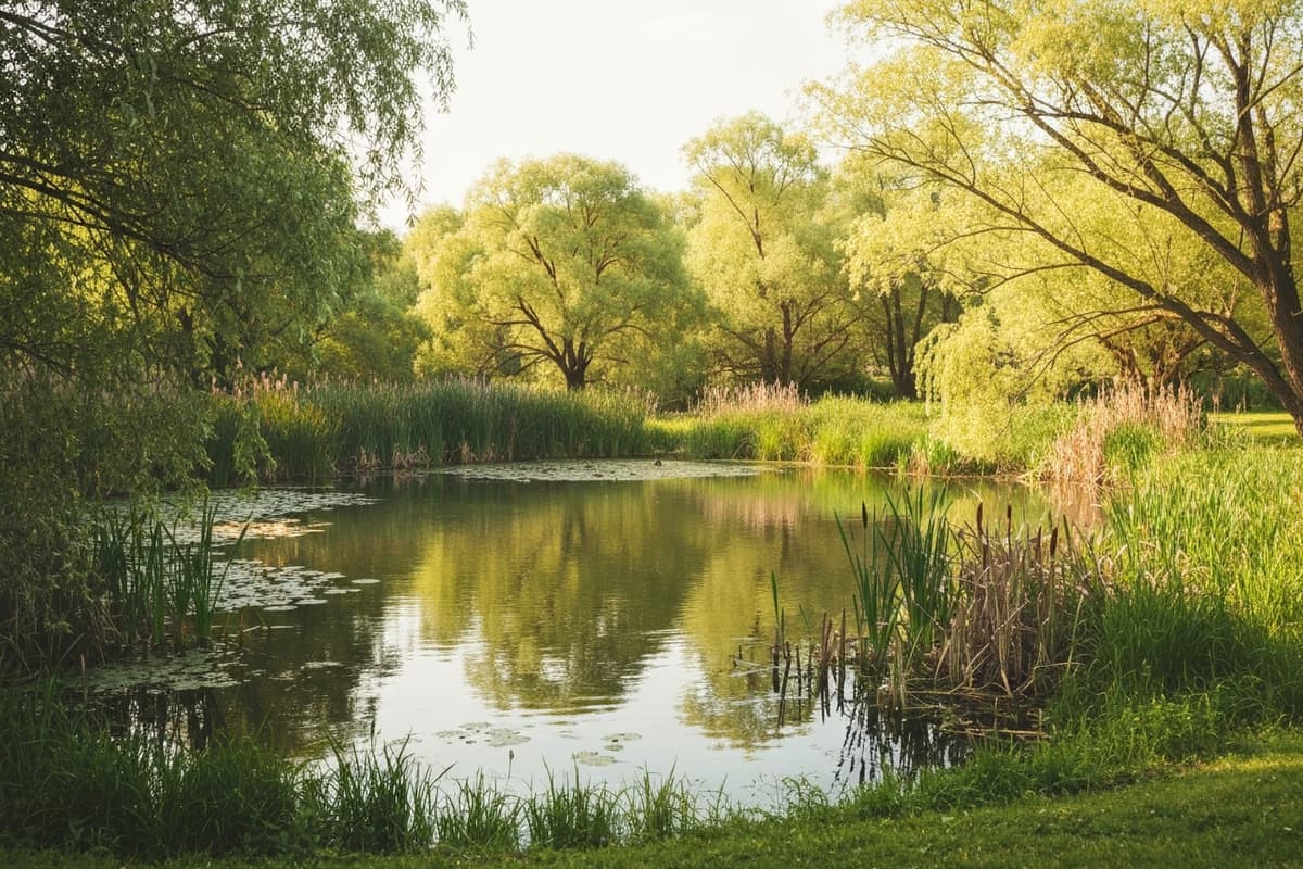
Counter-clockwise from the village, the path opens onto a small flat plain with a sheet of standing water at its centre. The lake's name is <strong>Pulnang-mot</strong>. Its perimeter is about 250 metres, and it sits inside the crater of the original Biyang-bong eruption — seawater and rainwater both feeding in, holding the salinity at a balance that puts it in the brackish category (neither marine nor freshwater).
What makes the lake worth a pause is what is underneath it. Beneath the surface is the throat through which magma once vented; above it now, calm water and reed beds, with migratory birds passing through in spring and autumn. A small pavilion sits at one corner of the lake — roughly the halfway mark of the perimeter walk, and the obvious place to sit down for ten minutes and reset.
Elephant Rock and the Hornito Field — Natural Monument No. 439
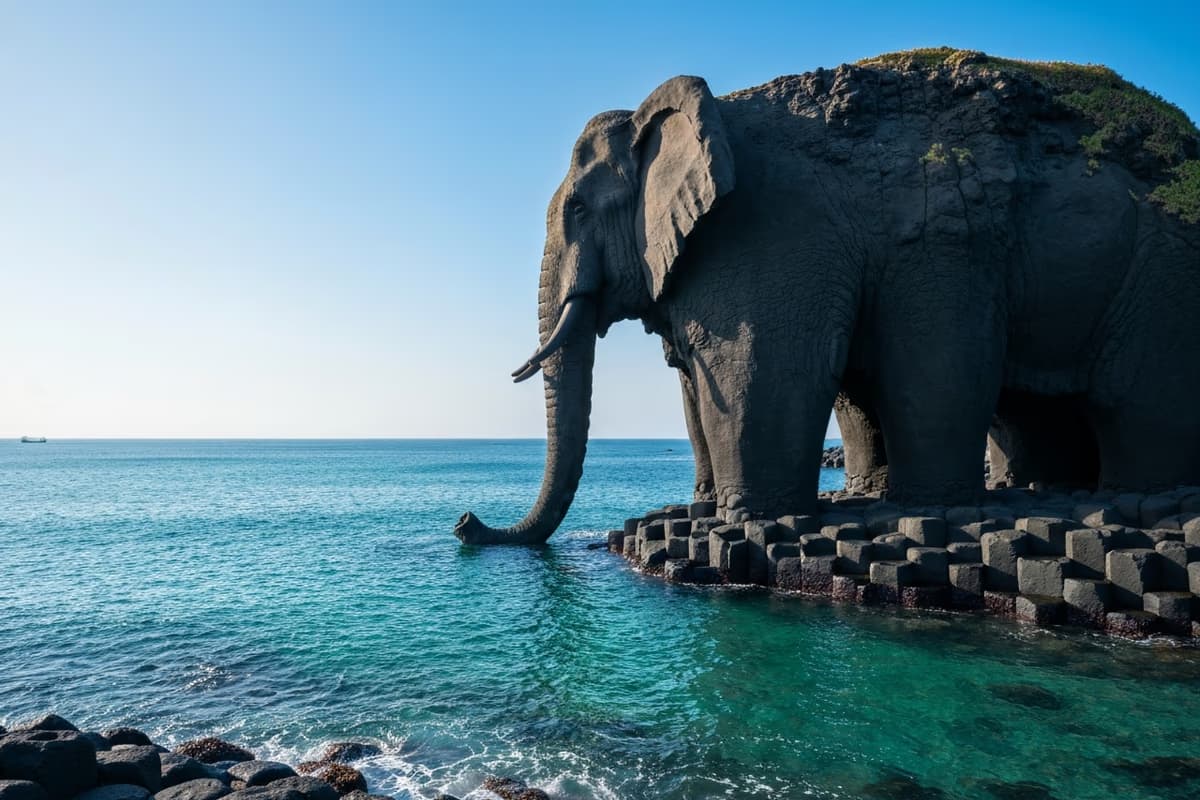
Past the pond and back along the coast, a single large dark rock comes into view. From a distance, the silhouette reads as an elephant lowering its trunk — the local name (Elephant Rock) has stuck for centuries. Looked at up close, the form is not just weathering: it is the collapsed remnant of a cluster of gas vents that once stood here.
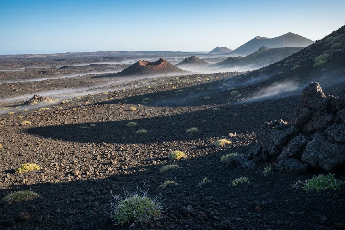
The shoreline immediately around Elephant Rock holds the headline feature of the island. <strong>Hornitos</strong> — small chimney-like structures formed when gas escapes from a moving lava flow — are an academic term used in English-language volcanology with the same Spanish-derived word ("little ovens"). Biyangdo's hornito field is acknowledged as one of Korea's best-preserved examples, and the entire zone is protected as <strong>Natural Monument No. 439</strong>. Reading lists and visiting itineraries for volcanology graduate programmes include this site.
Each hornito tower runs <strong>1 to 4 metres</strong> tall. Inside is the hollow throat through which gas once escaped; the outer surface is rough pyroclastic — the kind of crust geology textbooks display in cross-section diagrams. The hornitos are roughly 27,000 years old, formed in the late stages of the eruption that built the island. The closest analogue Western travellers may know is the hornito field on Lanzarote in the Canary Islands; Biyangdo's is at smaller scale but is the better-preserved of the two by most measures.
To the Lighthouse, and Hyeopjae From a Different Angle
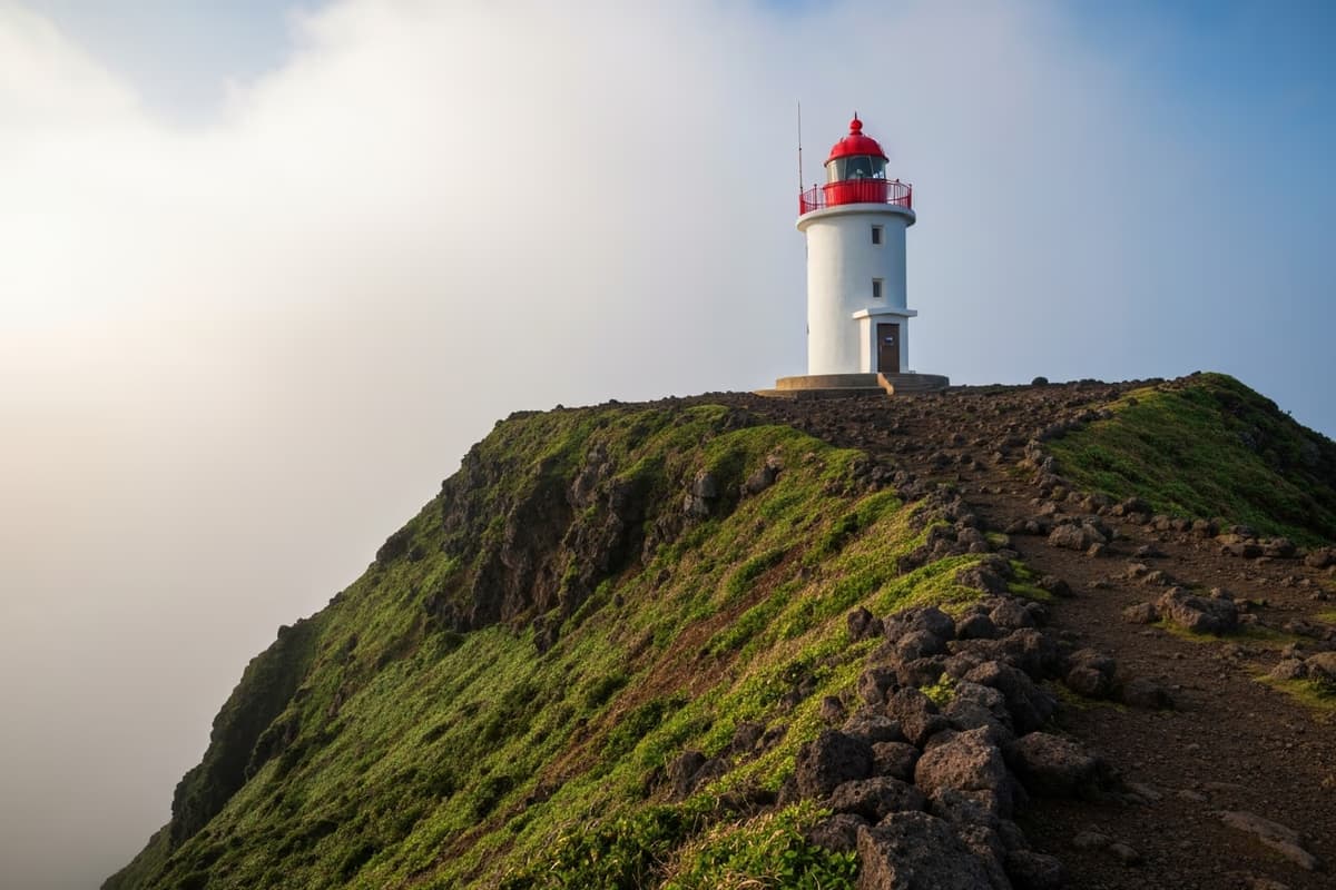
At the centre of the island rises <strong>Biyang-bong</strong>, 114 m above sea level. From the village, a 20-minute walk lands at the summit. The grade is gentle enough that "climb" is the wrong word; "stroll up" is closer. At the summit stands a small unmanned lighthouse, raised in <strong>1955</strong> and still working — the marker for the western shore of Jeju for more than seventy years now.
Look east from the lighthouse and the eye settles on a familiar shape: <strong>3 km / 1.9 miles</strong> away, the long white ribbon of Hyeopjae Beach where the morning started. From this angle, the small dots moving on the sand are people — including, an hour and a half ago, you. The trip from one's own footprint to the view of one's own footprint, with sea in between, is one of the small private rewards a short trek can give.
Look west and the horizon opens past the small islet of Chagwido and the headland of Suwolbong, with the bell-shape of Sanbangsan visible in clear weather. The island holds the entire western coast of Jeju in a single visual field.
Lunch in the Village
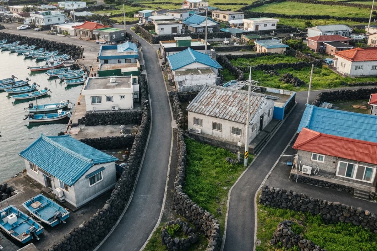
About <strong>150 people</strong> live on Biyangdo, mostly working in the fishery. A handful of small restaurants and a café cluster around the harbour. The dish that travels with the island's name is the <strong>Biyangdo seafood jjajangmyeon</strong> — a Korean-Chinese black-bean noodle bowl heaped with that day's seaweed, sea snail, and shellfish catch over the noodles. Each shop builds the version slightly differently — same name, a different bowl.
After the meal, a slow walk through the village turns up the texture of an island that is not a tourist set: laundry over a basalt wall, an older fisherman repairing a net by the harbour. The right move is to walk quietly, keep cameras at a respectful distance from doorways and people, and remember that the work the village is doing is older than the visitor.
Leaving the Island — Fifteen Minutes East to a Coastal Table
The return ferry runs on the printed schedule. The last departure in standard months is mid- to late-afternoon, and a normal half-day on the island (loop + summit + lunch) puts you back at the harbour comfortably ahead of that. Crossing back to Hyeopjae, the midday light has softened and the white sand has acquired long shadows.
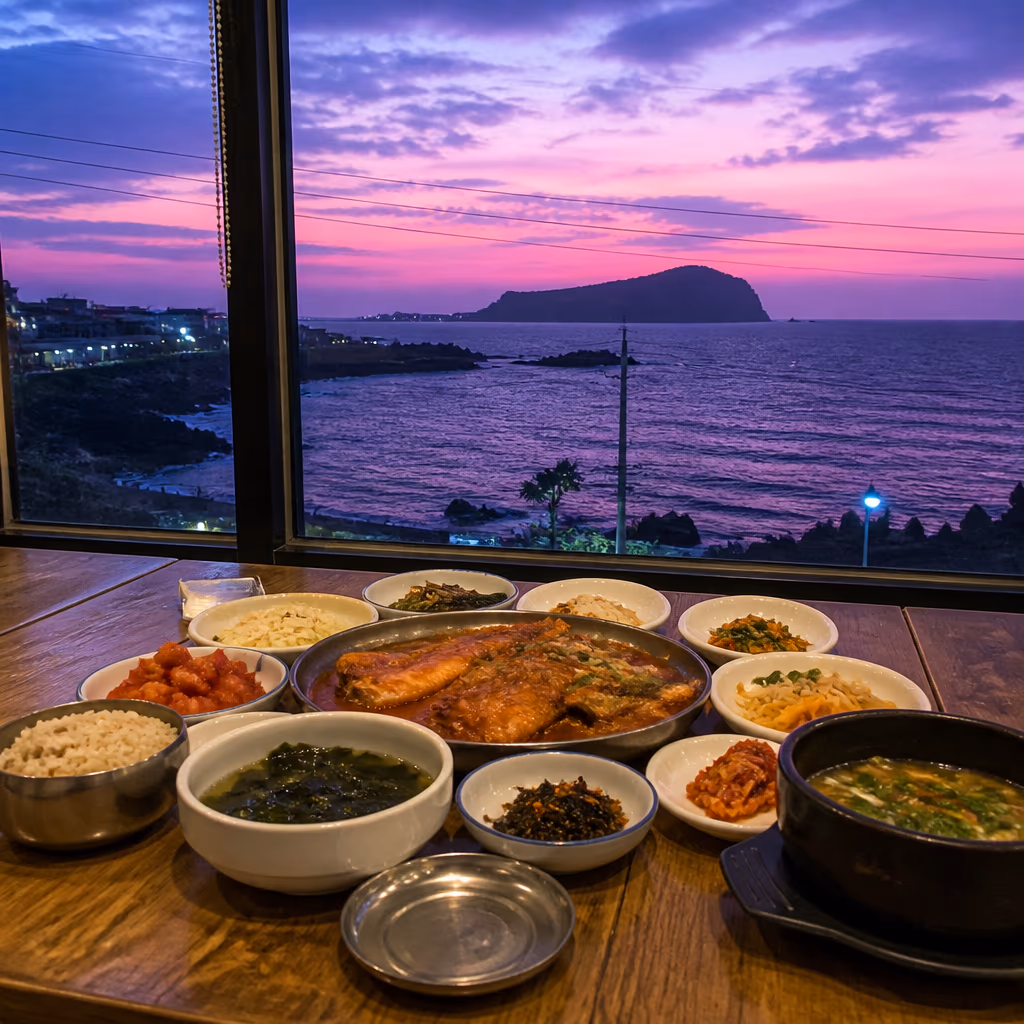
From the Hyeopjae public car park, Route 1132 along the coast carries you east about 14 km / 8.7 miles to Galchibada in Aewol → — about <strong>15 minutes</strong>. The legs have an opinion after the loop, the salt air has done its work on the appetite, and a window-seat table opens onto another stretch of the same emerald water. A whole silver hairtail landed off this coast that morning, braised in a spicy sauce that pulls the flesh cleanly along the grain — and the view from the summit, from an hour earlier, settles into one final composition at the table.
Practical Notes for the Ferry and the Trail
The ferry departs from <strong>Hyeopjae Port</strong> and <strong>Hallim Port</strong>. Schedules shift seasonally, and the Hallim ferry terminal counter holds the most reliable day-of information. Round-trip fare for an adult sits in the 10,000-won range (approximately USD 7). For up-to-date information in English, Visit Jeju in English carries seasonal updates. Hyeopjae Port is about 40 minutes by car from Jeju International Airport; intercity bus 202 from the Jeju City Bus Terminal puts a traveller within walking distance of the dock in about an hour. Real-time bus position lives at the Jeju Bus Information System.
The island has no buses or taxis. The whole visit happens on foot. Most of the perimeter is paved concrete with short unpaved sections; standard trainers are enough for the loop, but a pair with some ankle support is the better call around the hornito field, where the basalt surface is uneven. Pulnang-mot and the lighthouse stretch have very little shade — a hat and SPF 30+ are baseline, and a light windbreaker is worth packing for the summit, where the wind runs noticeably stiffer than at the village.
One short walk holds a thousand years of written record, twenty-seven thousand years of dated geology, a working seventy-year-old lighthouse, and the daily labour of a hundred and fifty people. The loop is short by the kilometre count but generous in what each step holds. Bring the salt air of the island back across the water, drive fifteen minutes east, and an entirely different composition sets itself on the table — the small island carrying its own afterimage as the dish arrives, and the day closing on the same coast under a different light.
Frequently Asked Questions
- Where does the Biyangdo ferry depart from, and how often does it run?
- The ferry runs from Hyeopjae Port or Hallim Port in Hallim-eup, Jeju City. Standard service is roughly 4–5 round trips daily, with seasonal schedule shifts — the Hallim ferry terminal has the most reliable day-of information. Round-trip fare for an adult sits in the 10,000-won range (~USD 7).
- How long does the Biyangdo loop walk take?
- The 3.5 km / 2.2 mile perimeter walks in 90 minutes to 2 hours at a comfortable pace. Adding the 20-minute climb to the Biyang-bong lighthouse at the centre of the island brings the full visit, including lunch in the village, to about 3 hours.
- What is Pulnang-mot, and why is it on the route?
- Pulnang-mot is a brackish crater lake (about 250 metres around) sitting inside the crater of the original Biyang-bong eruption — seawater and rainwater both feed it, holding salinity at a balance between marine and freshwater. The pavilion on its edge sits at the halfway point of the perimeter walk, and a 10-minute pause there is part of the standard rhythm.
- Why are the Biyangdo hornitos significant?
- Hornitos are small chimney-like structures formed when gas escapes from a moving lava flow — the term ("little ovens" in Spanish) is the standard English-language volcanology word. Biyangdo's field is one of the best-preserved hornito clusters in Korea, dated to roughly 27,000 years before present (the late stage of the island's formation), and the entire zone is protected as Natural Monument No. 439.
- Where do I eat lunch on Biyangdo?
- A small cluster of restaurants and a café operates in the harbour village. The dish that travels with the island's name is the Biyangdo seafood jjajangmyeon — a black-bean noodle bowl heaped with that day's seaweed, sea snail, and shellfish over the noodles. Each shop builds the bowl slightly differently.
- After the ferry back to Hyeopjae, how do I reach Galchibada in Aewol?
- From Hyeopjae Port, Route 1132 along the coast reaches Galchibada in Aewol in about 15 minutes by car — roughly 14 km / 8.7 miles east. A floor-to-ceiling ocean-view table and a wild-caught silver hairtail braise close the day on the same coast.
Carry the island salt across to a coastal table — 15 minutes east of Hyeopjae
From the lighthouse view to a wild hairtail braise
The salt air of a half-day around a small volcanic island is still on the skin when the ferry sets back down at Hyeopjae, and the eye still carries the summit view of the white sand beach from three kilometres out. Fifteen minutes east along the coastal road and the floor-to-ceiling window takes over the framing — a different stretch of the same emerald — and a whole hairtail braised in a spicy sauce closes the day from the table.
15 minutes east from Hyeopjae Port to Galchibada Aewol via Route 1132 →