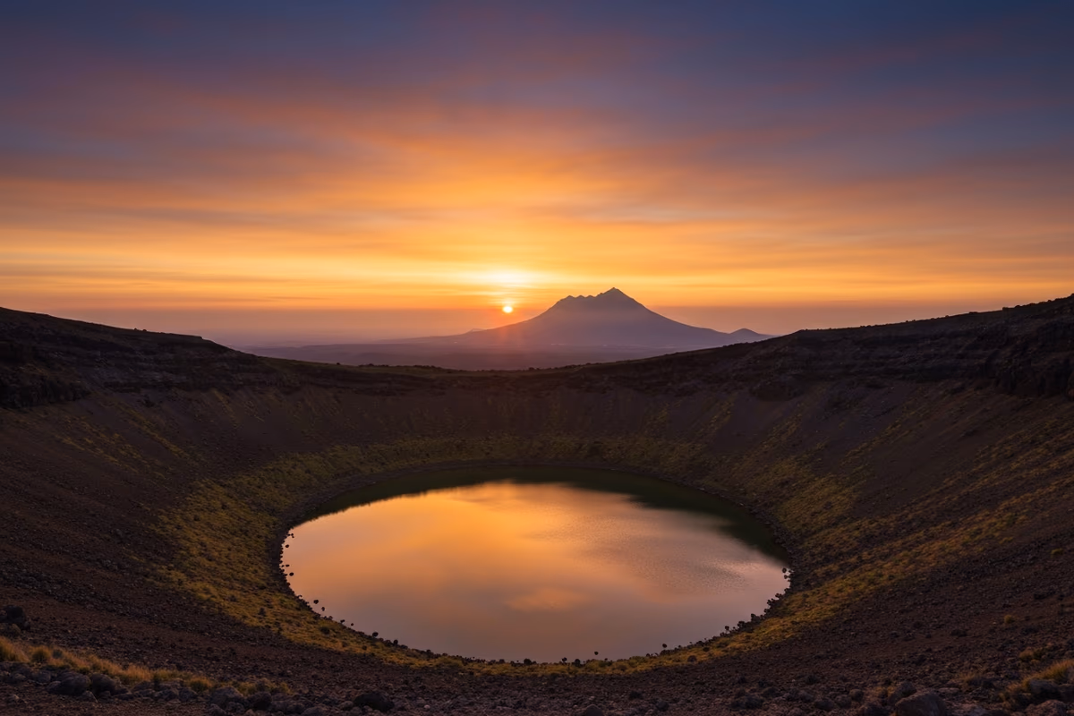
Geum Oreum — A Mirror Lake Inside the Crater and a Hallasan Sunset Skyline
A 20-Minute Climb to a 427-Metre Volcanic Cone Where the Sun Drops Between a Reflecting Pond and the Tallest Mountain in South Korea
Geum Oreum (금오름, also called Geumak Oreum) sits in Geumak-ri, Hallim-eup on Jeju's mid-mountain west, at 427 m (1,400 ft) elevation. The walk from the free parking lot to the summit covers about 800 m (0.5 mile) over a gentle gradient and takes 20–30 minutes. A small crater lake (a true volcanic crater pond, not a typical highland reservoir) sits at the centre of the summit bowl, held by a clay basal layer that prevents drainage. The 360-degree summit panorama reaches Hallasan's ridgeline to the east, Biyangdo and Chagwido to the west, and Sanbangsan's bell-shape to the south. About 10 minutes by car from Saebyeol Oreum, with significantly fewer weekday visitors — typically 10–20 on the sunset rim versus several hundred at Saebyeol. The drive to Galchibada in Aewol runs about 25 minutes east via the Pyeonghwa-ro / Route 1132 sequence.
Jeju is widely cited as holding around <strong>360 oreums</strong> — small parasitic scoria cones that pepper the island around Hallasan. Among that wide population, the cones with a standing body of water in the crater are extremely rare. Most volcanic craters are leaky by structural default, draining percolating rainwater downward through fractured basalt within hours. The exception is a small ridge in Geumak-ri in Hallim-eup. At <strong>427 m (1,400 ft) elevation</strong>, this cone holds a small lake at the centre of its summit bowl — and the name of the cone is Geum Oreum.
The cone is also called Geumak Oreum, taking the administrative village name. Both labels point at the same hill. The walk to the summit is short and reads as a gentle stroll rather than a climb, but the density of what waits inside that short walk — a crater pond, a 360-degree island panorama, and a sunset window with Hallasan in frame — outpaces every comparable oreum by a wide margin. For Western visitors who have done Diamond Head on Oahu (Hawaii's most photographed crater walk) or Cinder Cone in Lassen Volcanic National Park, the family resemblance is clear; Geum Oreum is the Korean parallel at a more compact scale, with a clearer wide-view payoff.
A 20-Minute Walk to the Summit
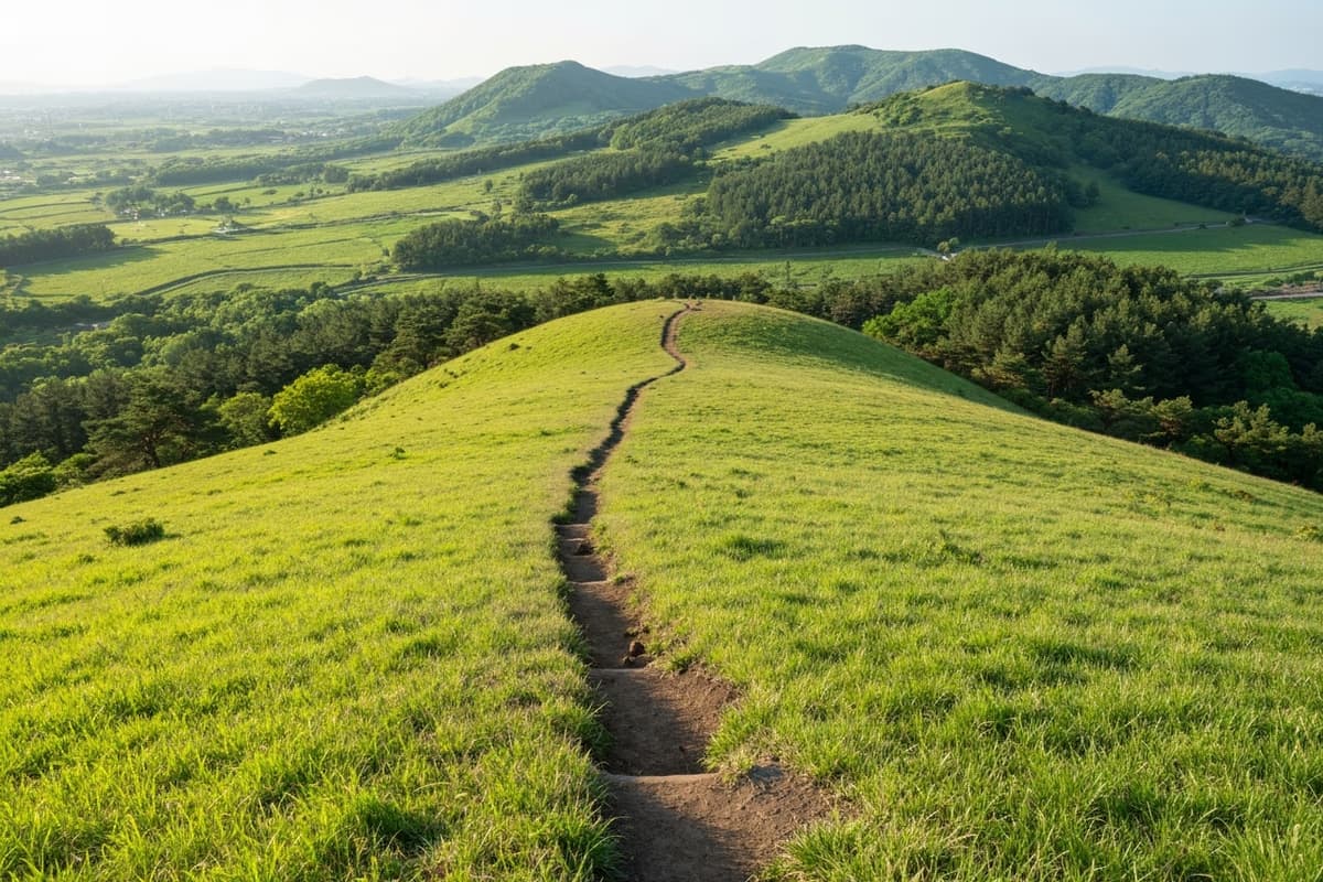
From the parking lot to the summit covers about <strong>800 m / 0.5 mile</strong>. The first third runs across flat earth; the middle section pitches slightly steeper, but the steeper part is short and never demanding. <strong>20 minutes at standard pace, 30 minutes at an easy one</strong> — neither figure requires hiking poles or a specific shoe. A regular trainer is enough; trail runners with some ankle support are the better call after rain, when the earth surface softens.
The path is bordered by low shrubs and Hallasan-fed grassland — milk-vetch and wildflowers in spring, silver pampas grass in autumn, and a base of green-and-clay tones year-round. The Saebyeol Oreum pampas display, ten minutes south by car, covers an entire ridge; Geum Oreum's grass texture by contrast is more sculpted, ridge by ridge along the side of the cone. Each oreum carries a slightly different stand of vegetation, and the variation between two cones this close together is one of the small unscientific pleasures of working through the network.
The parking lot is free and there is no entrance fee. A single toilet block sits near the car park. No night lighting along the trail — for sunset visits, the descent uses a phone torch or a small head torch; arriving back at the car park in full darkness is otherwise routine.
The Crater Lake — A Mirror Held by Clay
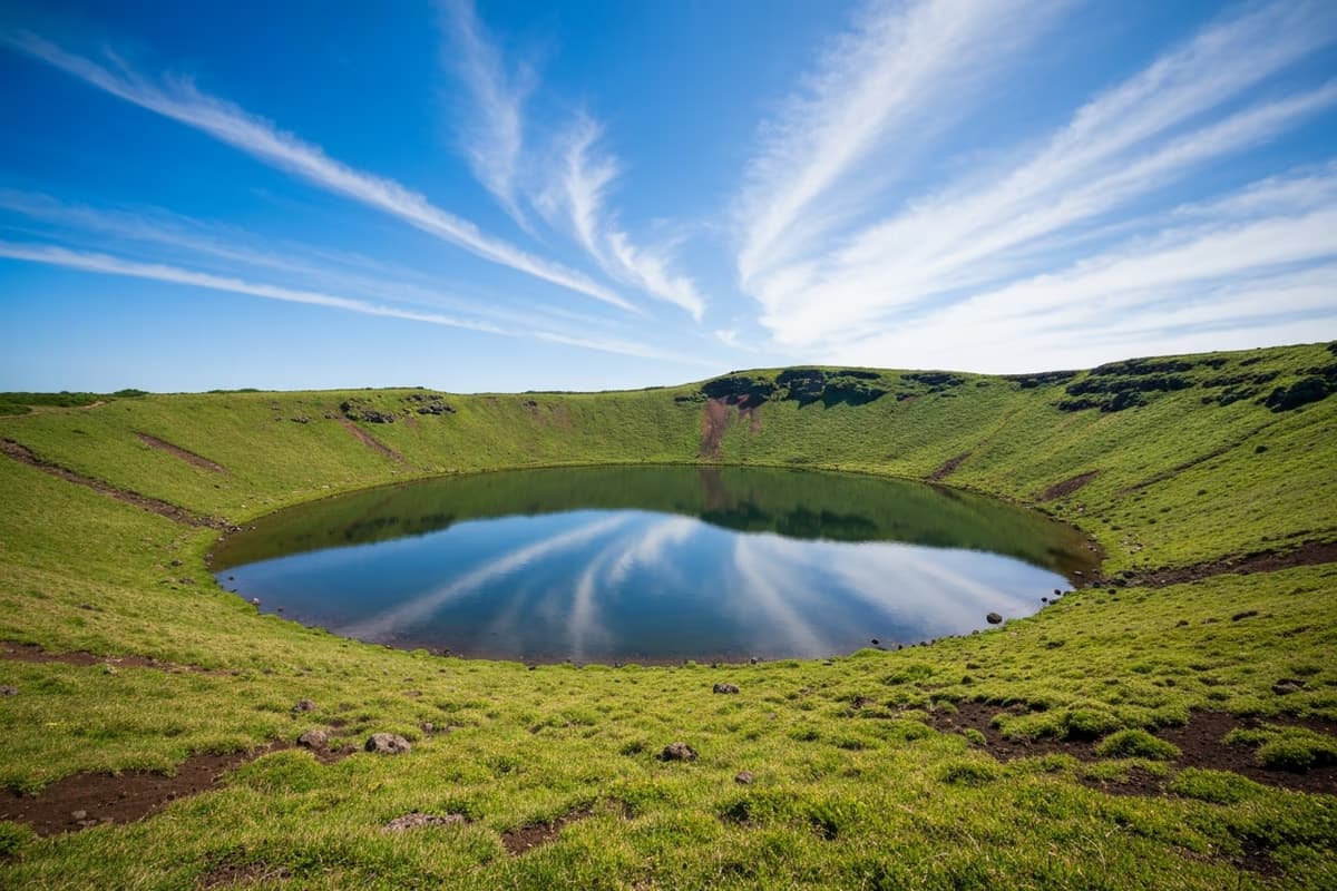
At the summit, the first thing the eye drops to is the lake. Its perimeter is short — a few hundred metres — and the inside of the crater frames it into a tidy bowl shape. From the rim above, the view reads as if a precise piece of landscape sculpture has been set into the volcano. On still days, the surface reflects the sky and the surrounding grass cleanly, and the lake reads as a mirror seated at the centre of the cone.
The pond is fed by rainwater and groundwater seepage, and it persists because the floor of the crater is sealed by a fortuitous clay layer that resists drainage — geologically uncommon on a basalt island. Late summer can pull the water level down during long dry stretches, but full evaporation across all four seasons is the exception rather than the rule. The lake is essentially permanent.
There are routes that drop down inside the crater toward the water, but the inner basin is a seasonal protected zone and access can be restricted. The clean reading of the lake — and the cleaner photographic composition — is from the outer rim looking down. The single circular path around the summit covers the panorama and the lake together in under 15 minutes of walking.
The 360-Degree Panorama — Hallasan in the East, Biyangdo in the West
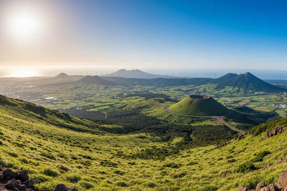
From the rim, raise the eye and the panorama opens in every direction. East holds the <strong>Hallasan ridgeline</strong>, drawn cleanly against the sky with the mid-mountain plains carrying their softer green textures up to the base. On the clearest days, the outline of <strong>Baekrokdam</strong> — the crater lake at the summit of Hallasan, the tallest peak in South Korea at 1,947 m — becomes faintly visible on the central ridge.
West catches Hyeopjae Bay and the small volcanic islet of <strong>Biyangdo</strong> sitting just offshore. Further west still, the cliffs of Suwolbong and the islet of Chagwido appear on the horizon. South frames the <strong>bell-shape of Sanbangsan</strong> and the line of wind turbines that runs through Hangyeong-myeon. North runs out toward the lower plains of Jeju City.
Standing at the rim, the whole western half of Jeju is held in a single visual field. Among the 360 oreums that share this island, this scale of unobstructed sightline is a small minority — perhaps a dozen oreums offer a comparable wide view, and most are harder to reach. The combination of a 20-minute approach and a complete panorama is what places Geum Oreum on the standard advanced Jeju itinerary.
The Sunset — A Different Compositional Logic From Saebyeol

What makes Geum Oreum draw photographers specifically is the sunset geometry. Saebyeol Oreum's sunset image is a horizontal one: pampas-grass field across the foreground, sun dropping behind it, the lower ridge of mid-mountain plains stretching out beneath. Geum Oreum's sunset is vertical and layered — the crater lake at the rim of the foot, the rim grass at mid-height, and the Hallasan skyline anchoring the back wall of the frame. The same forty-minute sunset window renders as two genuinely different photographs at these two cones, despite their being a ten-minute drive apart. For travellers comparing Jeju sunset rim hikes, the cleanest summary is: <em>Saebyeol</em> for the panoramic pampas, <em>Geum</em> for the layered crater + mountain composition.
The window opens about <strong>40 minutes before the published sunset time</strong>. The early warm-light phase paints Hallasan's face golden-orange and slowly migrates down the ridge toward the rim. The middle phase reaches the crater pond, where the reflected surface picks up the same orange against the green grass framing. The final minutes hold the sun on the western horizon past Biyangdo, with hard, short shadows running across the rim.
Staying past the official sunset is the move. A 20-minute magic hour follows, with the sky transitioning through deep orange, violet, and finally cobalt. The pond surface holds the last light longest, and that final stretch — sometimes longer in late autumn — is the headline shot most landscape photographers actually wait for.
A Quieter Rim Than Saebyeol Oreum
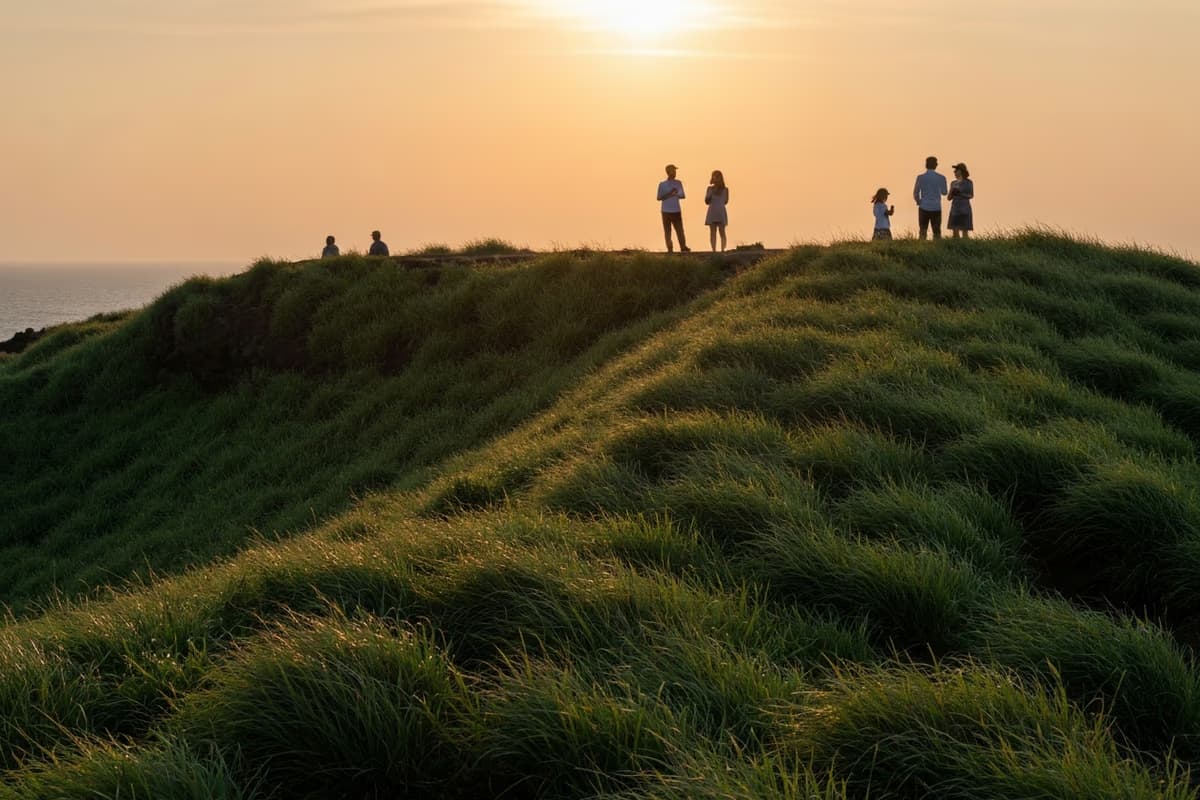
Saebyeol Oreum has been the headline west-Jeju sunset for two decades. The reputation has brought the crowd that comes with the reputation. On a peak weekend, Saebyeol's rim can hold several hundred sunset watchers, with cameras lining the western edge two or three deep. Geum Oreum, ten minutes by car from Saebyeol, runs roughly an order of magnitude quieter on a weekday: <strong>typically 10–20 sunset visitors on the rim</strong> rather than several hundred. The shoulder space, the calm of the composition, and the ability to set a tripod without negotiation are all genuinely different.
The quiet is a weekday phenomenon. On peak summer weekends, weekend photographers from Jeju City and the resort cluster make the short drive over, and the rim can carry 50–80 visitors at sunset. Even then, it stays a smaller venue than Saebyeol. For a fully relaxed sunset, a weekday visit is the simple recommendation — Tuesday and Wednesday are the quietest days; Saturday is the noisiest.
A short etiquette note for any rim popular with photographers: keep voices low during the final ten minutes of the sunset window, do not step in front of set-up tripods unless invited, and pack out everything you carry in. The crater is a protected zone and even a discarded tissue is conspicuously visible against the grass.
25 Minutes West to Galchibada — The Day's Final Note

When the magic-hour light on the pond has faded into evening blue, the rim grass begins to cool quickly. A small head torch on the descent keeps the loose earth path safe. From the Geum Oreum car park, the route runs Pyeonghwa-ro (Route 1135) and then the coastal Route 1132, putting the drive to Galchibada in Aewol → at about <strong>25 minutes</strong>.
The 360-degree composition that closed at the rim — the Hallasan skyline, the western coast, the still pond — translates into a different register at the table. A floor-to-ceiling window opens onto the night ocean, and a wild-caught silver hairtail landed off this coast that morning rests on the plate. The braise pulls the flesh clean along the grain, much the way the rim trail had stayed clean through the climb. As either the closing meal of a sunset day-trip or the opening dinner of an Aewol evening, the timing fits without effort. Reserving in advance lets the post-sunset drive run unhurried.
Getting There and Practical Notes
The address is around 산52-1번지, Geumak-ri, Hallim-eup, Jeju City. From Jeju International Airport, the drive is about <strong>35 minutes</strong>; from Saebyeol Oreum, about 10 minutes. Public transport is limited: from the Jeju Intercity Bus Terminal, route 252 toward Hallim drops walkers at the nearest stop, with a further walk or short taxi ride to the trailhead. Bus times and real-time positions live at the Jeju Bus Information System. Seasonal opening windows for the crater interior and current trail conditions update at Visit Jeju in English as conditions change.
A short packing list for the visit. The summit rim carries almost no shade; in midday a hat and SPF 30+ are baseline. Sunset wind at the rim is reliably stronger than at the parking lot — a light windbreaker keeps the magic-hour window enjoyable rather than just endurable. A small phone torch or head torch is essential for the descent after dark. Regular trainers handle the path in dry conditions; the earth surface softens after rain, and a pair of trail runners with some ankle support is the safer call.
A mirror pond at the centre of a crater, a 360-degree view that reaches Hallasan in the east and Biyangdo in the west, and a sunset window that holds the highest peak in South Korea inside the same frame as a small still body of water on a volcanic rim. Twenty minutes up, twenty minutes of light at the rim, and twenty-five minutes west to a coastal table at the close. One short climb, one deep composition, and one final plate that holds the same coast in a third light — the cleanest single-day arc the western mid-mountain offers.
Frequently Asked Questions
- Are Geum Oreum and Geumak Oreum the same place?
- Yes. Both names point at the same 427 m scoria cone in Geumak-ri, Hallim-eup. The administrative naming convention uses "Geumak Oreum"; the shorter conversational form is "Geum Oreum." Either label leads to the same trailhead.
- How long does the climb to the summit take?
- About 20 minutes at standard pace, 30 minutes at an easy one. The trail covers roughly 800 m / 0.5 mile from the parking lot. The gradient is gentle for most of the route, with one short steeper section. Hiking shoes are not necessary — a standard trainer is enough; trail runners with some ankle support are the better choice after rain.
- What kind of lake sits in the crater?
- A small rainwater-and-groundwater-fed pond at the centre of the summit bowl, held in place by a fortuitous clay layer at the crater floor that prevents drainage. The arrangement is geologically uncommon on a basalt island, where craters typically drain quickly. The lake persists across all four seasons, with some level drop in late summer dry stretches. The interior basin is a seasonal protected zone; the cleaner reading and the cleaner photograph are both from the outer rim looking down.
- How does the Geum Oreum sunset compare with Saebyeol Oreum?
- Both are headline west-Jeju sunset oreums and they sit a 10-minute drive apart, but the compositional logic is different. Saebyeol Oreum offers a horizontal panoramic sunset over pampas grass; Geum Oreum offers a vertical layered sunset with the crater lake in foreground, the rim mid-frame, and the Hallasan skyline as the back wall. Saebyeol carries several hundred visitors on a weekend rim; Geum Oreum typically holds 10–20 on a weekday and 50–80 on a busy weekend.
- How long is the drive from Geum Oreum to Galchibada in Aewol?
- About 25 minutes west via Pyeonghwa-ro (Route 1135) connecting to the coastal Route 1132. Timing-wise, finishing the sunset rim window and driving down to a floor-to-ceiling ocean-view table for a late dinner of wild-caught silver hairtail closes the day on a single arc.
- How crowded is Geum Oreum at sunset?
- On weekday evenings, typically 10–20 visitors on the rim — quiet enough to set a tripod without negotiating space. On peak summer weekends the rim can hold 50–80 visitors. For a fully relaxed sunset, weekdays (especially Tuesday and Wednesday) are the cleanest choice; Saturday is the noisiest.
From a crater-rim sunset to a coastal table — 25 minutes west
The Hallasan skyline you watched from the rim, now on the plate
When the magic-hour purple has faded from the crater pond and the rim grass starts to cool, a small head torch carries the descent. Twenty-five minutes west along Pyeonghwa-ro and the coastal road, a floor-to-ceiling window opens onto the night sea, and a wild-caught silver hairtail braised in a spicy sauce closes the day from the table — the same skyline that anchored the sunset translated into a different register on the plate.
25 minutes west from Geum Oreum to Galchibada Aewol via Pyeonghwa-ro + Route 1132 →