Hallasan Yeongshil Trail — The Shortest Summit Route From Jeju West
A 5.8 km One-Way Trail From 1,280 m to 1,700 m Through Columnar Basalt, Korean Firs, and Alpine Wetland
The Yeongshil Trail is the shortest of Hallasan's designated routes — 5.8 km from Yeongshil Rest Stop (1,280 m) to Witse-oreum Shelter (1,700 m), about 2 hours 30 minutes one-way. The route cuts through trachyte columnar joints formed by volcanic activity roughly 250,000 years ago and the Seonjakji-wat alpine wetland. After descending, Route 1100 carries you down to the Aewol coast in about 40 minutes — closing the climb with a sunset dinner at the western shore.
From Jeju's west, this is the quickest way to meet Hallasan. The Yeongshil Trail starts at roughly 1,280 metres on Route 1100, climbs about 5.8 km to the Witse-oreum shelter at 1,700 m, and takes around 2 hours 30 minutes at an honest pace — the shortest gateway into the volcano's alpine ridge. Following a stone stairway flanked by towering columnar joints, you ascend through Korean fir groves with the western coastline laid out below at every turn.
Compared to Hallasan's other routes, Yeongshil is shorter in both distance and time — yet the visual density may be the highest of any approach. Threading through the Pyeongpung Rock columnar joints and the Seonjakji-wat wetland in such a compact span gives even moderately fit beginners a real taste of Hallasan's vertical ecological transition. For Western hikers familiar with the Cuillin Ridge on Skye, the Tongariro Alpine Crossing in New Zealand, or the Cirque de Gavarnie in the French Pyrenees, Yeongshil reads as the East Asian peer at compressed scale.
The Full Yeongshil Layout
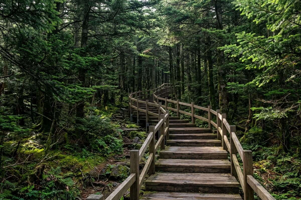
The trailhead is at Yeongshil Rest Stop. The climb to Witse-oreum Shelter covers about 3.7 km; an additional 2.1 km continues to the South Wall Junction. The full round trip runs 11.6 km in 4 to 5 hours total. The first 1.5 km is a gentle stretch of earthen path and wooden boardwalk — a clean warmup. From there the Pyeongpung Rock section starts and the gradient firms up noticeably, but with each step the field of view widens and altitude registers in the legs.
Mid-height hiking boots with ankle support are ideal, but a stiff-soled trainer can manage. The stone steps are spaced evenly enough to hold a rhythm, and benches at regular intervals let you keep your own pace. Before heading out, the Hallasan National Park English site carries same-day weather and access updates — checking the morning of saves a long drive on a closed day.
Pyeongpung Rock — The Columnar Joints Yeongshil Holds
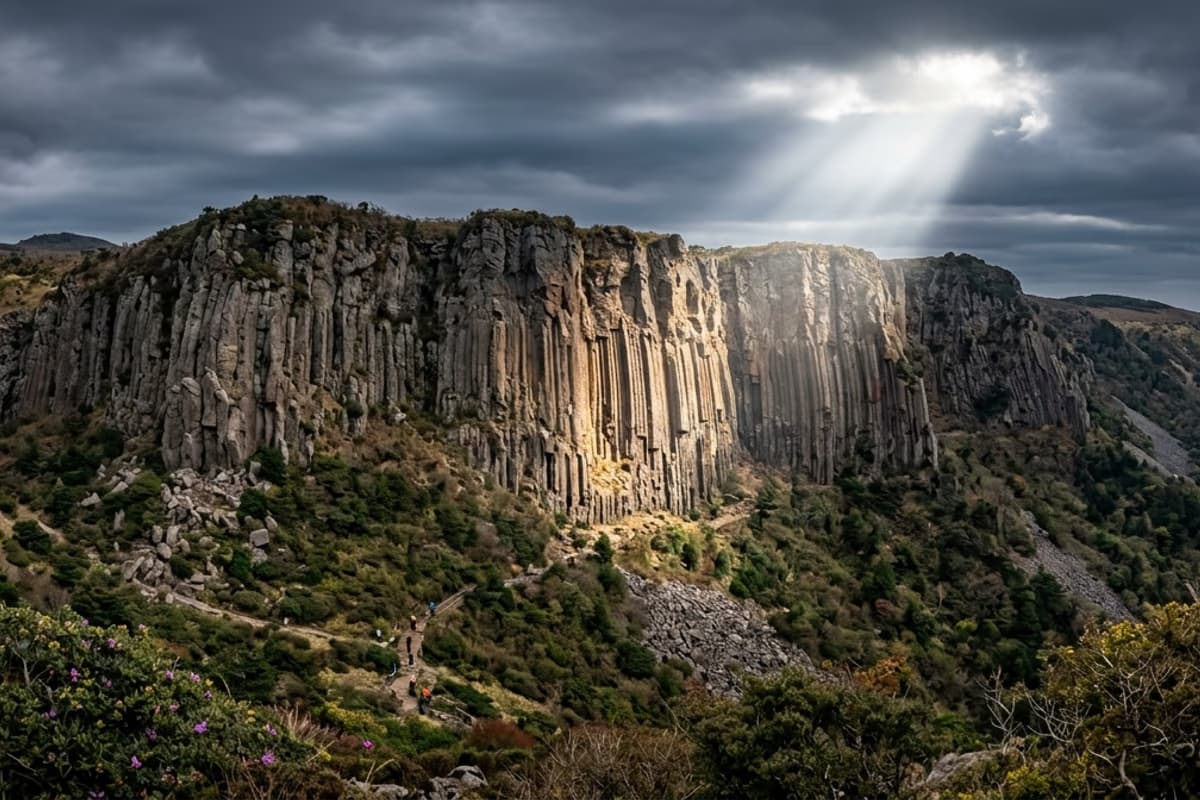
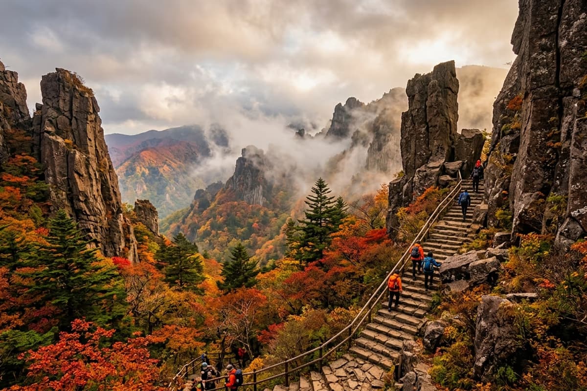
Around 1,400 metres the trail enters Pyeongpung Rock — a row of roughly 100-metre trachyte columnar joints standing as dozens of vertical pillars. Formed by volcanic activity about 250,000 years ago, the wall takes on a singular atmosphere after rain, when fog flows through the columns and slides down between them. Nowhere else on Hallasan can you walk past columnar joints of this scale at this elevation.
In spring, royal azalea spills pink between the columns; in autumn, maple lays a red gradient across the grey-brown surface. The same standing position rewards a different photograph every season. For sharpest texture on the vertical grain, before 10 a.m. — when backlight has receded — is the cleanest light window.
Witse-oreum Shelter and Seonjakji-wat Wetland
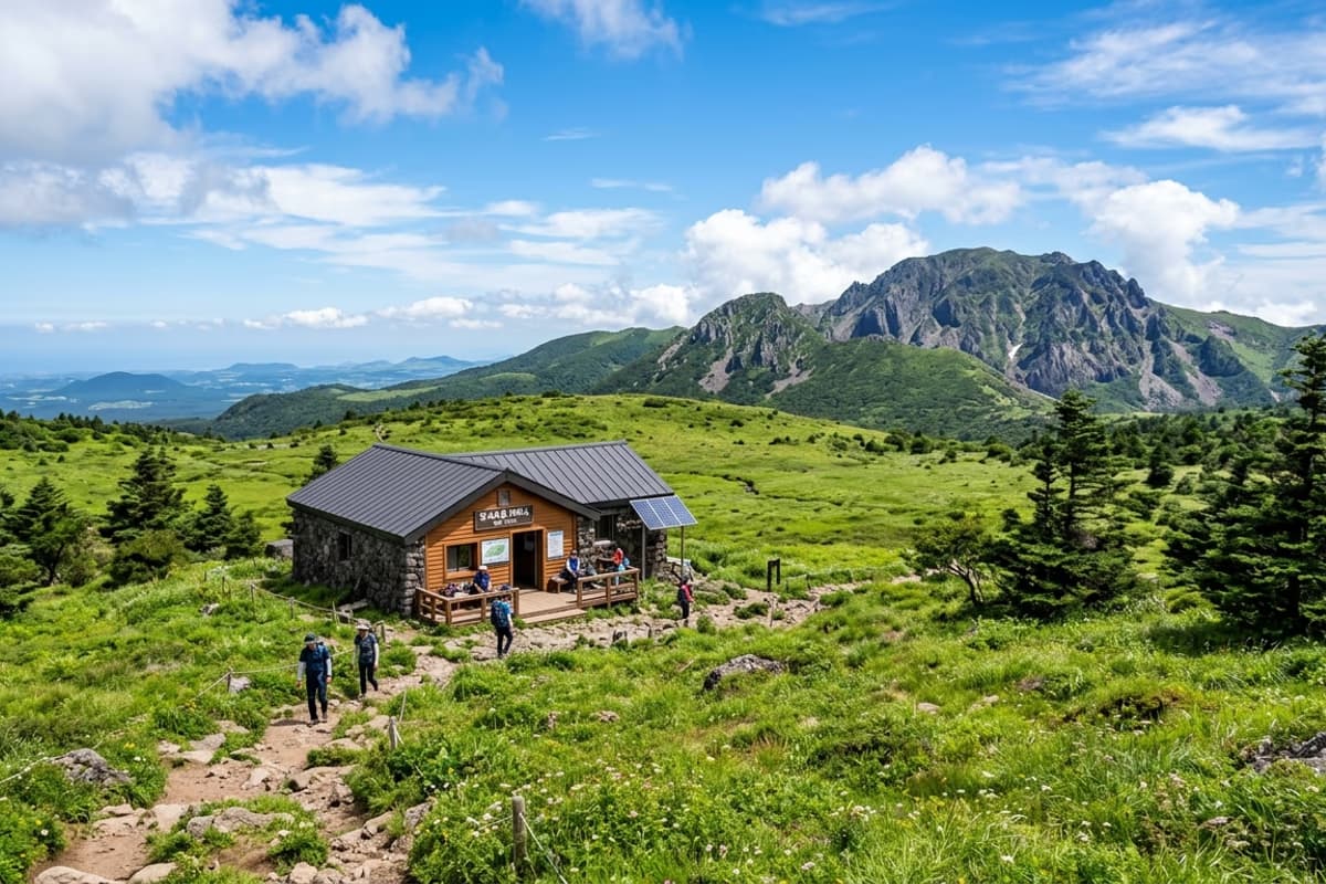
About 40 minutes past Pyeongpung Rock you arrive at the Witse-oreum Shelter at 1,700 m — the junction where the Yeongshil, Eorimok, and Donnaeko routes meet, and the heart of Hallasan's alpine ecosystem. The Seonjakji-wat wetland around the shelter holds Korea-endemic Korean fir and crowberry communities, and during the spring thaw meltwater pools on the wetland surface like a mirror reflecting the sky.
Baengnokdam (the summit crater lake) is not directly visible from here, but pressing 2.1 km further to the South Wall Junction brings the Hallasan summit silhouette into view. Cup noodles and warm drinks are sold at the shelter; cooking is prohibited on the trail and all packed-in trash must descend with you.
Yeongshil's Four Seasons — Four Different Mountains
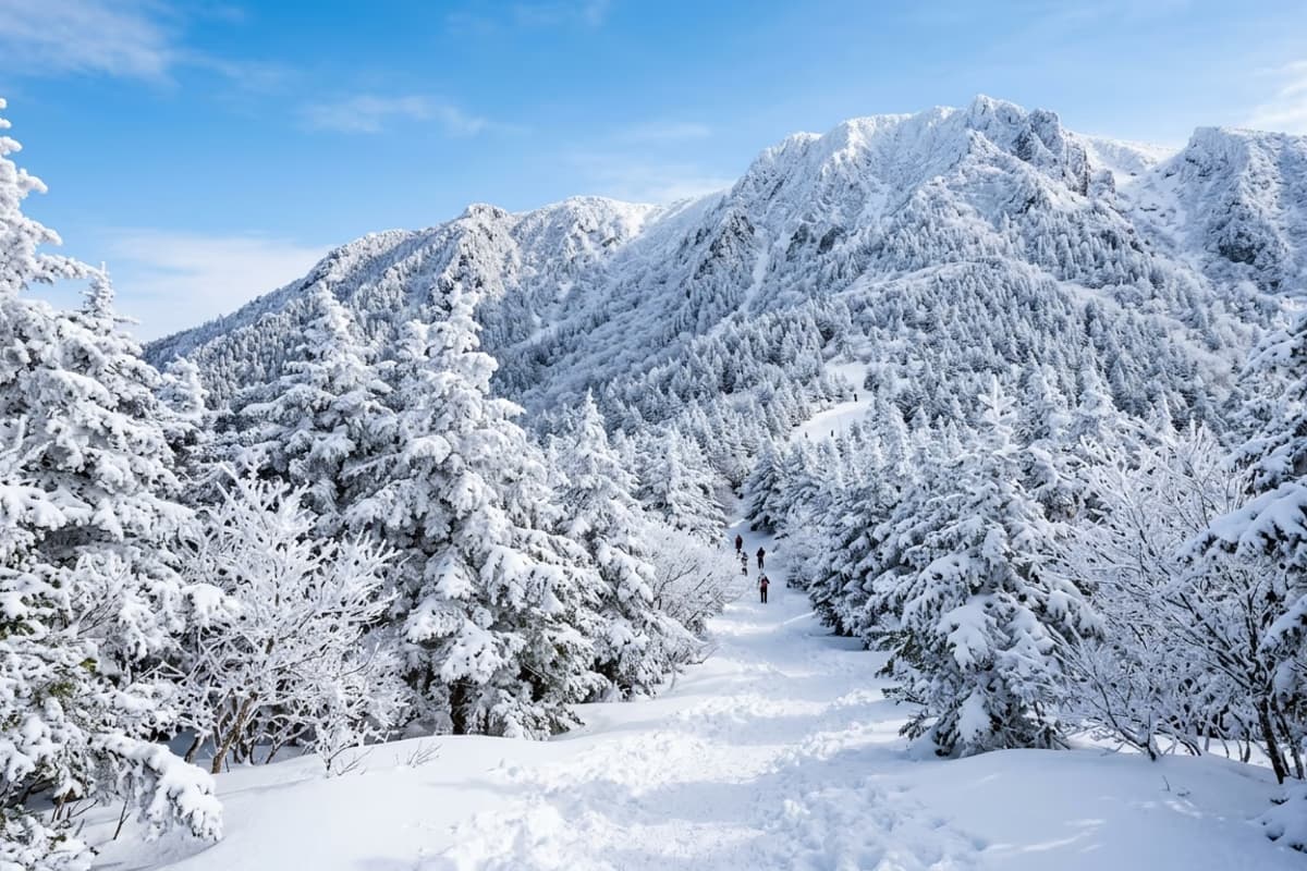
Walking the same trail four times produces four different mountains. Spring (April–May) lays a pink carpet of royal azalea before Pyeongpung Rock. Summer (July–August) sends water mist rising along the ridges through deep green canopies. Autumn (October–November) lights up the Korean fir forest in red and gold — Hallasan's most decorated foliage stretch. Winter (December–February) coats the fir branches in <em>sanggodae</em> rime ice that blooms like white flowers and turns the trail into a near-monochrome landscape.
Yeongshil's winter rime is a phenomenon you can only meet on Hallasan, and the highest probability of seeing it is the clear morning after dawn temperatures drop below -10 °C / 14 °F. The reason serious hikers stand at the trailhead just before the winter cut-off time (9 a.m.) is not the schedule — it is that one possible window.
Descent and Access Hours
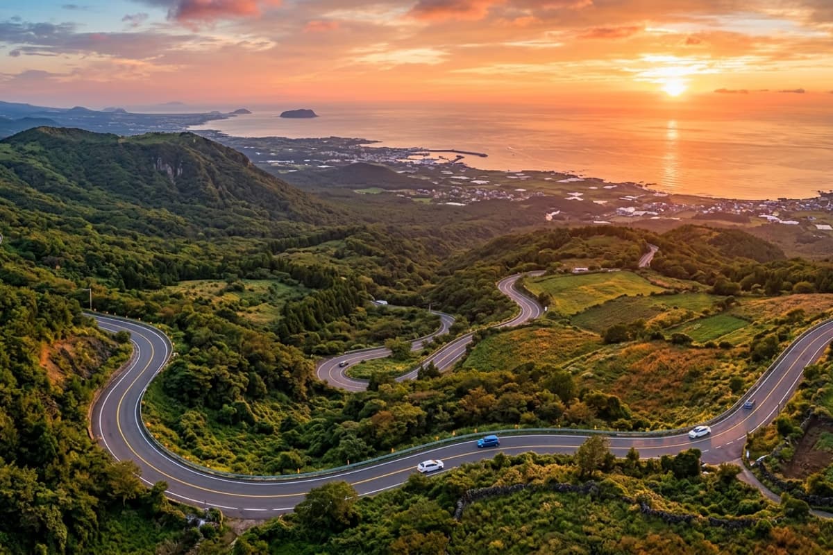
From Yeongshil Rest Stop, descending west via Route 1100 puts the Aewol coast about 40 minutes away by car. After a climb, the first proper meal often defines the lasting impression of the day, and the timing of a westward coastal drive lines up cleanly with sunset spreading across the windshield — exactly the window an evening dinner reservation suits.
The last-entry times vary by season: winter (November–February) is 9 a.m., spring/autumn (March–April, September–October) is noon, and summer (May–August) is 1 p.m. Temperatures on Hallasan shift quickly with altitude, so a windbreaker belongs in the pack even in summer, and at least one litre of water is the minimum. There is no water station between the trailhead and the shelter, and dehydration can creep in unnoticed as elevation rises. Trekking poles especially reduce knee load on the stone-stair descent through Pyeongpung Rock.
Frequently Asked Questions
- How long does the Hallasan Yeongshil Trail take?
- From Yeongshil Rest Stop to Witse-oreum Shelter is about 2 hours 30 minutes one-way, with the round trip running 4.5 to 5 hours at an average pace. Continuing to the South Wall Junction adds another hour each way.
- When does Yeongshil close to new entries?
- Last entry is 9 a.m. in winter (November–February), noon in spring and autumn (March–April, September–October), and 1 p.m. in summer (May–August). The trail can be closed entirely in severe weather — checking the Hallasan National Park site on the morning of your climb is mandatory.
- Can a beginner hiker handle Yeongshil?
- Yes — it is the shortest and lowest-difficulty of Hallasan's designated routes, and beginners can take it on. That said, the Pyeongpung Rock stairway has a real gradient, and ankle-supporting footwear plus trekking poles make a meaningful difference on the way down.
- How does parking work at Yeongshil?
- A free lot at Yeongshil Rest Stop holds about 100 vehicles. On weekends and during peak season, arriving before 8 a.m. is the safe call. The lot fills early, and shoulder-parking along Route 1100 is enforced against.
After descending Hallasan, a 40-minute drive to a coastal dinner table
Lay down the ridge altitude and arrive at a table facing the sea
With the vertical grain of Pyeongpung Rock still in the eye, the descent down Route 1100 unrolls the coastline back into view. At a table facing the same sea through floor-to-ceiling glass, the first spoonful on an empty stomach closes the climb cleanly — the last impression of the day arriving on a plate.
About 40 minutes from Yeongshil Rest Stop to Galchibada Aewol via Route 1100 →