Suwolbong — A 4 km UNESCO Geo Trail Across an 18,000-Year-Old Volcanic Section
The Hydrovolcanic Tuff Cliff Korea Reads Like a Textbook, on Jeju's Far Western Shore
Suwolbong is a 77-metre hydrovolcanic crater in Gosan-ri, Hangyeong-myeon, Jeju City, formed roughly 18,000 years ago when rising magma met groundwater. Its coastal cliff exposes a tuff sequence — layered volcanic ejecta of varying density — with such textbook clarity that the area was designated a UNESCO Global Geopark site in 2010. The 4 km geo trail around the hill is level enough for an easy walk, and the summit offers a single-frame view of Chagwido and Jagunae Port. Galchibada Aewol is about 35 minutes east by car.
UNESCO designated this 77-metre hill as part of a Global Geopark. With Hallasan's 1,950-metre Baengnokdam crater right behind it and roughly 360 oreum dotting the island's lower slopes, the question of why this small hill earned its own listing has a single answer: the cliff face under the hill opens up like a textbook page of Korean Peninsula volcanic history. That hill is Suwolbong in Gosan-ri, Hangyeong-myeon.
The summit itself is reachable on a short walk. But the view across that short walk is not just panorama. The soil under the foot, the cliff face beyond it, and the coastal walking route that follows that cliff for roughly 4 km — all of it is landscape that began with a single eruption 18,000 years ago. For Western readers, the geological context is closest to Surtsey off Iceland (1963 birth, near-perfect hydrovolcanic exposure) or the Capelinhos cinder cone in the Azores (1957–58, similar tuff sequence) — both still-studied examples of exactly the eruption type that built Suwolbong.
Hydrovolcanic Eruption — When Magma Meets Seawater
Where a typical eruption sends magma straight up through the surface, a <em>hydrovolcanic</em> eruption is one in which the rising magma meets groundwater or seawater on its way up. In English the technical term is <em>hydromagmatic eruption</em>; in Korean, <em>suseong bunchul</em>. The instant magma's heat hits water, a massive quantity of steam flashes off, and the resulting blast is much more violent than a standard magmatic eruption.
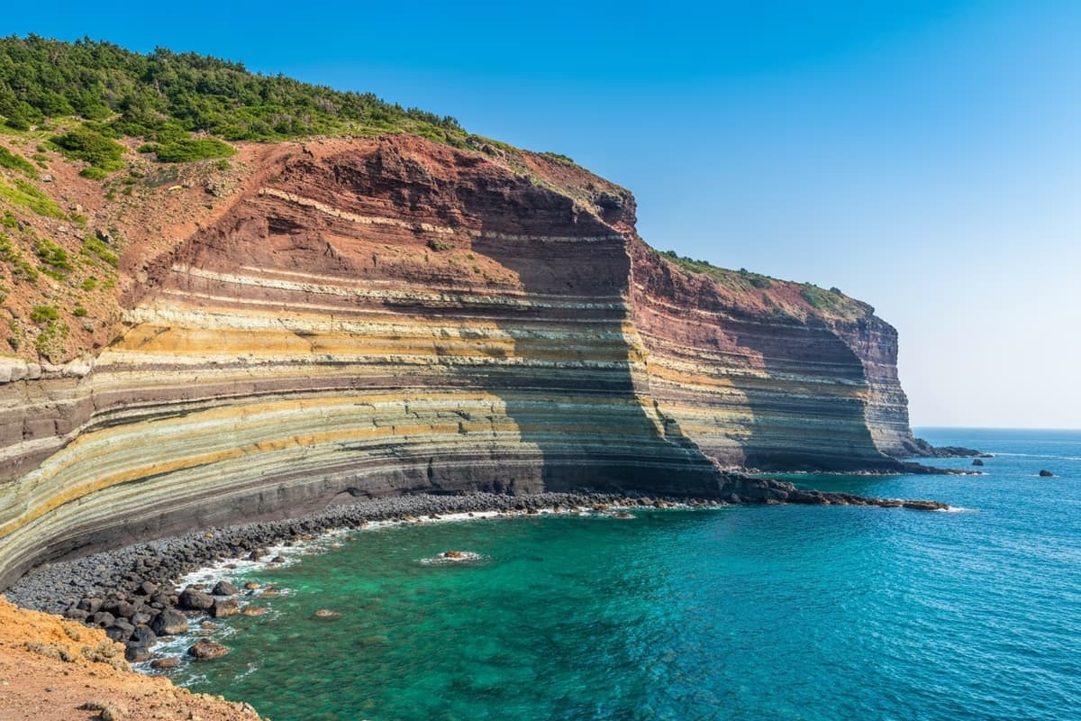
Roughly 18,000 years ago, when Suwolbong formed, a single hydrovolcanic eruption took place here. Magma rising from deep below met seawater near the surface, and the brief moment of contact sent enormous volumes of volcanic ash and lapilli (gravel-sized ejecta) into the air. As those particles fell back to the ground and stacked up, what we now call Suwolbong took shape. The cliff face that resulted now reads as a series of colour bands — each band a different mixture of particle sizes, frozen in sequence.
Geologists call this a <em>tuff</em> sequence. Not a single uniform stone but interleaved bands of coarse lapilli and fine ash, each layer recording a different phase of the same eruption. It is, in effect, a book where each page captures a different second of a single explosion. That clarity is exactly why UNESCO designated the area as a Global Geopark site in 2010.
A 4 km Geo Trail — Level Coastal Walking
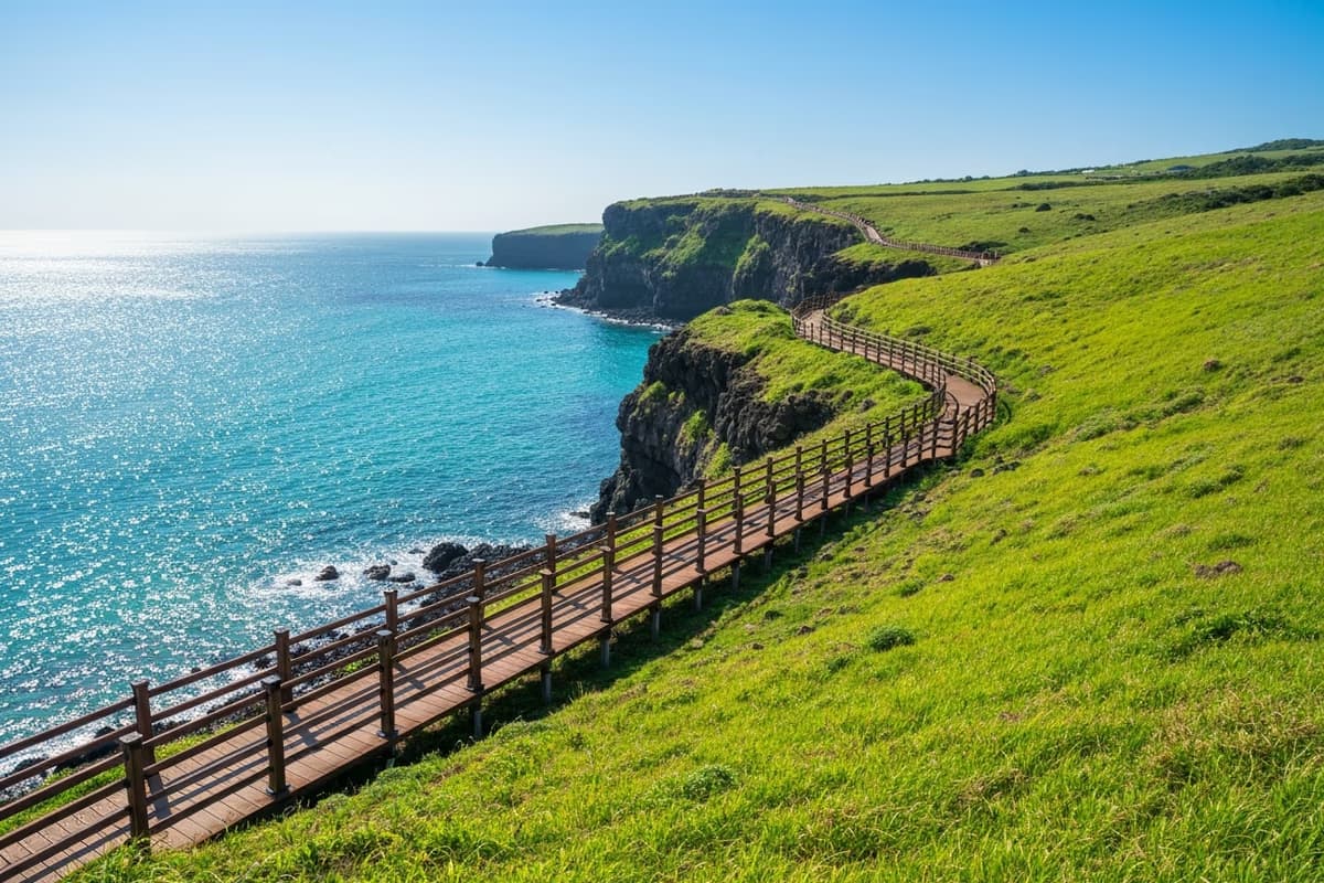
The walking route around Suwolbong runs about 4 km along the coast. The standard loop starts at Jagunae Port — directly facing Chagwido — climbs to the Suwolbong summit, then loops back to Jagunae. Total time at an easy pace is 1 hour 30 minutes to 2 hours.
Most of the path is level earthen track with short boardwalk sections — closer to a comfortable walk than a hike. Short auxiliary decks allow close views of the tuff sequence at multiple stops, each marked with interpretive panels in both Korean and English. Foreign visitors can follow the same information as Korean visitors throughout.
The route suits family visits and walks with older travellers. There is, however, very little shade along long stretches, so a hat and sunscreen are essential in high-sun seasons. A couple of restrooms and small rest areas sit along the way.
From the Summit to Chagwido in a Single Frame
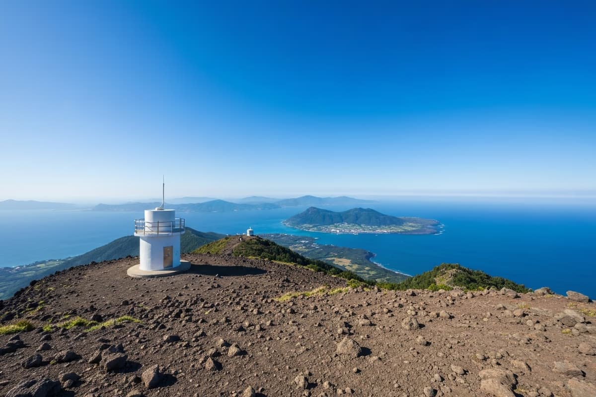
A small unmanned weather station sits at the summit. Standing beside it, the small uninhabited island of Chagwido sits centred in the field of view about 2 km offshore. The visual rhythm rhymes with the view of Biyangdo from Hyeopjae, but Chagwido is uninhabited — and that single fact rewrites the feel of the view.
Sunset toward Chagwido is one of the most distinctive western-Jeju glow spots. Where most coastal sunsets drop the sun behind the open horizon, here the sun descends alongside the small Chagwido silhouette. Compared with Geumneung's sunset beside Biyangdo, the texture reads rougher by a clear notch.
Southward, the coastline curls toward Sanbangsan and Songaksan; eastward, the long Hallasan ridge stretches. Small hill though it is, the view width at the summit holds its own against any vantage point on Jeju's western half.
Walking Across a Page of Volcanic Time
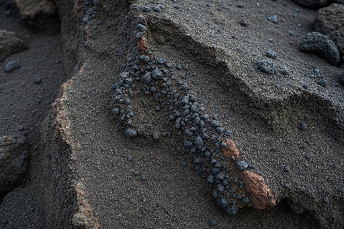
Walking the geo trail, there are spots where you can place your hand directly on the cliff face. What looks at first like ordinary brown soil resolves up close into a layered mixture of particles in varying textures. A band of lapilli — pieces smaller than a fingertip — sits in clean order, then a band of dust-fine ash covers it, then the pattern repeats.
Reading along this single face is, in effect, reading the eruption's timeline in reverse. The bottom layer of larger particles records the early-phase debris that fell close to the vent; lighter ash accumulates above; a new pulse of intense ejection repeats the pattern. The face itself is a geological diary.
Some sections of the cliff face are inside academic protection zones, and chipping off or carrying away any material is strictly prohibited. The rule is look, touch where allowed, and leave the page intact.
Two Close Sites — Chagwido and Jagunae Port
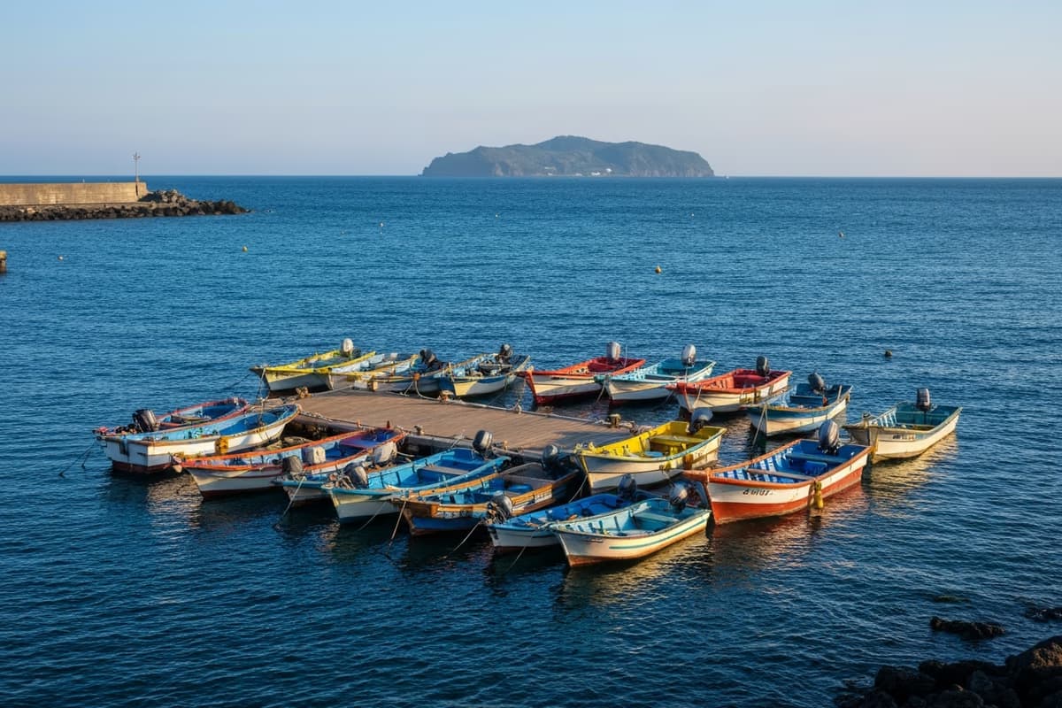
After looping Suwolbong, boarding the Chagwido ferry at Jagunae Port is the natural next step. The one-way crossing takes about 10 minutes, and including a loop walk on Chagwido itself the whole pairing closes inside a half day.
The triple package — Suwolbong trail, Jagunae cafes and small boats, and the Chagwido crossing — is the most efficient configuration available within Hangyeong-myeon. You meet the same landscape in three different registers: cliff face, port-edge, and from a boat on the open water.
35 Minutes East — Closing the Cliff Walk at the Restaurant
After looping the geo trail and a brief stop at the summit, light fatigue rises into the legs and appetite sharpens. From the Suwolbong area parking lots, Route 1132 (Iljuseo-ro) puts the entrance to Galchibada Aewol → about 35 minutes east.
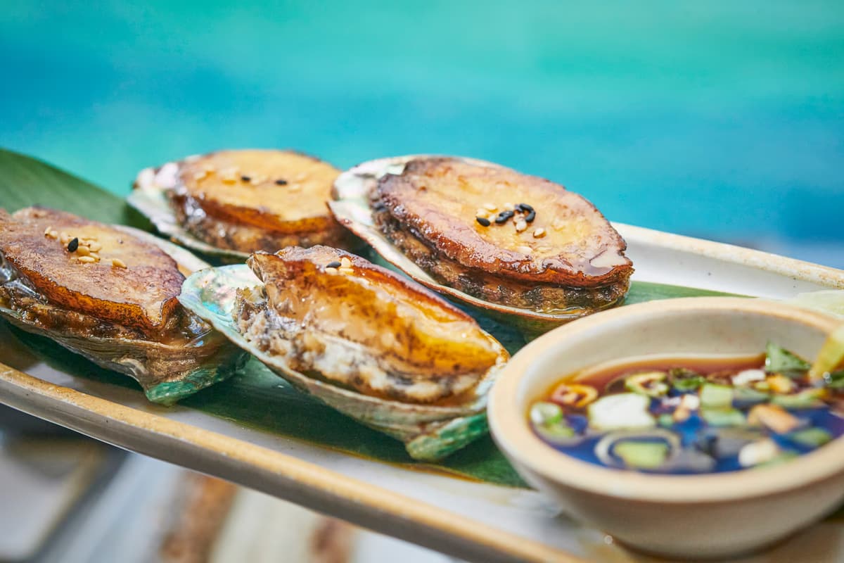
The 18,000-year-old texture you traced with your fingertips on the cliff face, and a wild silver hairtail flaking along its own grain at the table — two textures meeting in a single meal. The volcanic-island ground that fishermen have lived on for generations now arriving at the plate as a precisely tweezered fish each dawn; the same island writing one line at a time on a cliff face and one line at a time on a fillet.
Getting There and Practical Notes
The address is Gosan-ri, Hangyeong-myeon, Jeju City. From Jeju International Airport the drive runs about an hour; from the Jeju Intercity Bus Terminal, intercity bus 202 or Hangyeong-bound bus puts you here in about an hour and a half. Real-time schedule at Jeju Bus Information System; seasonal trail and academic-event updates on the Visit Jeju English portal.
Public parking is available near Suwolbong and at Jagunae Port; the two lots are 5 minutes apart by car, so either drop point puts the trailhead within a short walk. There is no admission fee.
A short packing note. The coastal trail has little shade, so a hat and sunscreen are essential. The path is level but 4 km is not short, so closed shoes are recommended. The cliffside decks have safety fencing, but on high-wind days stepping all the way to the deck edge is better avoided. If you are pairing this with Chagwido, confirm the ferry schedule at the Jagunae ticket booth in advance.
A small hill earning a single volume of certification is not common. The soil under the foot and the cliff face beside it lay out, page by page, exactly how a single 18,000-year-old eruption unfolded. After tracing those pages in one spot, 35 minutes east brings you to a meal grown on the same island. A volcanic textbook and a wild fish on a plate — the same island's time, unfolded in two textures along a single rare itinerary.
Frequently Asked Questions
- Why was Suwolbong designated as a UNESCO Global Geopark site?
- The coastal cliff exposes a tuff sequence laid down by a hydrovolcanic eruption roughly 18,000 years ago, with such textbook clarity that the chronology of a single eruption can be read directly from the face. UNESCO recognised the area as a Global Geopark site in 2010.
- How long does the Suwolbong geo trail take?
- About 4 km starting from Jagunae Port, summit, and back to Jagunae. 1 hour 30 minutes to 2 hours at an easy pace. Most of the route is level — comfortable for families and visitors travelling with older companions.
- How does a hydrovolcanic eruption differ from a regular eruption?
- In a hydrovolcanic eruption, rising magma meets groundwater or seawater near the surface; the steam flash sends out a much stronger blast than a standard eruption, ejecting volcanic ash and lapilli of varying particle sizes that stack into the layered tuff sequence Suwolbong is built on.
- Can I pair Suwolbong with Chagwido?
- Yes. Ferries to Chagwido depart from Jagunae Port at the foot of Suwolbong, with a 10-minute one-way crossing. Pairing the Suwolbong geo trail and a Chagwido walk easily fits inside a half day — the standard Hangyeong-myeon itinerary.
- How long is the drive from Suwolbong to Galchibada Aewol?
- Route 1132 (Iljuseo-ro) eastbound puts Galchibada Aewol about 35 minutes away. The standard close is a floor-to-ceiling ocean-view seat with braised or grilled wild silver hairtail for a late afternoon or early dinner.
- Can I touch the cliff face along the trail?
- Close viewing and contact on the boardwalk sections is allowed, but parts of the cliff fall inside academic protection zones, and detaching or removing any material is strictly prohibited. Look and touch where allowed — leave the page intact.
After tracing a page of volcanic time, 35 minutes east to the table
From an 18,000-year-old cliff face to a single grain on a plate
When the page traced under your fingertips on the cliff face has settled into the legs as light fatigue, it is time to move. Thirty-five minutes east on Iljuseo-ro, a floor-to-ceiling window opens onto the sea again. An 18,000-year-old grain and that morning's grain meet on a single plate.
About 35 minutes from the Suwolbong Geo Trail to Galchibada Aewol →