Hangpaduri Fortress — Goryeo Sambyeolcho Last Stand (1271-1273)
A Military-History Guide to a Korean Last-Stand Site Built in the Same Decade as Edward I's Welsh Castles and the Fall of Xiangyang
Hangpaduri Anti-Mongol Site (National Historic Site No. 396) is the 1271-1273 fortress of the Sambyeolcho — a Goryeo Korean military elite that refused the Mongol Empire's peace settlement and made their final stand on Jeju Island. The earthen outer wall ran approximately 6 kilometers, enclosing 1.09 million square meters; the inner citadel was around 750 meters in circumference. The site fell to a 10,000-strong joint Goryeo-Mongol force in April 1273, ending the 40-year Goryeo resistance to Mongol invasion. Today the site preserves walking paths along the wall trace, an exhibition hall with excavated arrowheads and iron armor fragments, and the Sunuibi Memorial. Free admission, year-round, 09:00-18:00 (last entry 17:30). Galchibada in Aewol is 15-20 minutes by car.
A six-kilometer earthen wall trace runs along a mid-mountain slope on Jeju's western coast — a fortress built in 1271 by a group of Korean soldiers who had refused to accept that the Mongol Empire had won. Their war was already lost. The Goryeo court had surrendered eleven years earlier. The Sambyeolcho — the elite military unit at the center of this article — knew it. They crossed the sea anyway, built the wall anyway, and held out for two more years before a joint Goryeo-Mongol expeditionary force ended their resistance in April 1273.
This piece is for military-history travelers — readers who would visit Edward I's Welsh castles, the Crusader fortress at Krak des Chevaliers, or Masada with a copy of Josephus in their bag. Hangpaduri belongs in that company. Its construction (1271) overlaps almost exactly with Edward I's invasion of Wales (1277 onwards) and falls in the same five-year window as the fall of Xiangyang to the Mongols (1273) — the three sieges representing parallel responses to expansionist empire across thirteenth-century Eurasia. Reading Hangpaduri as part of that wider story changes what the walls feel like underfoot.
A 6-Kilometer Earthen Fortress on a Mid-Mountain Slope
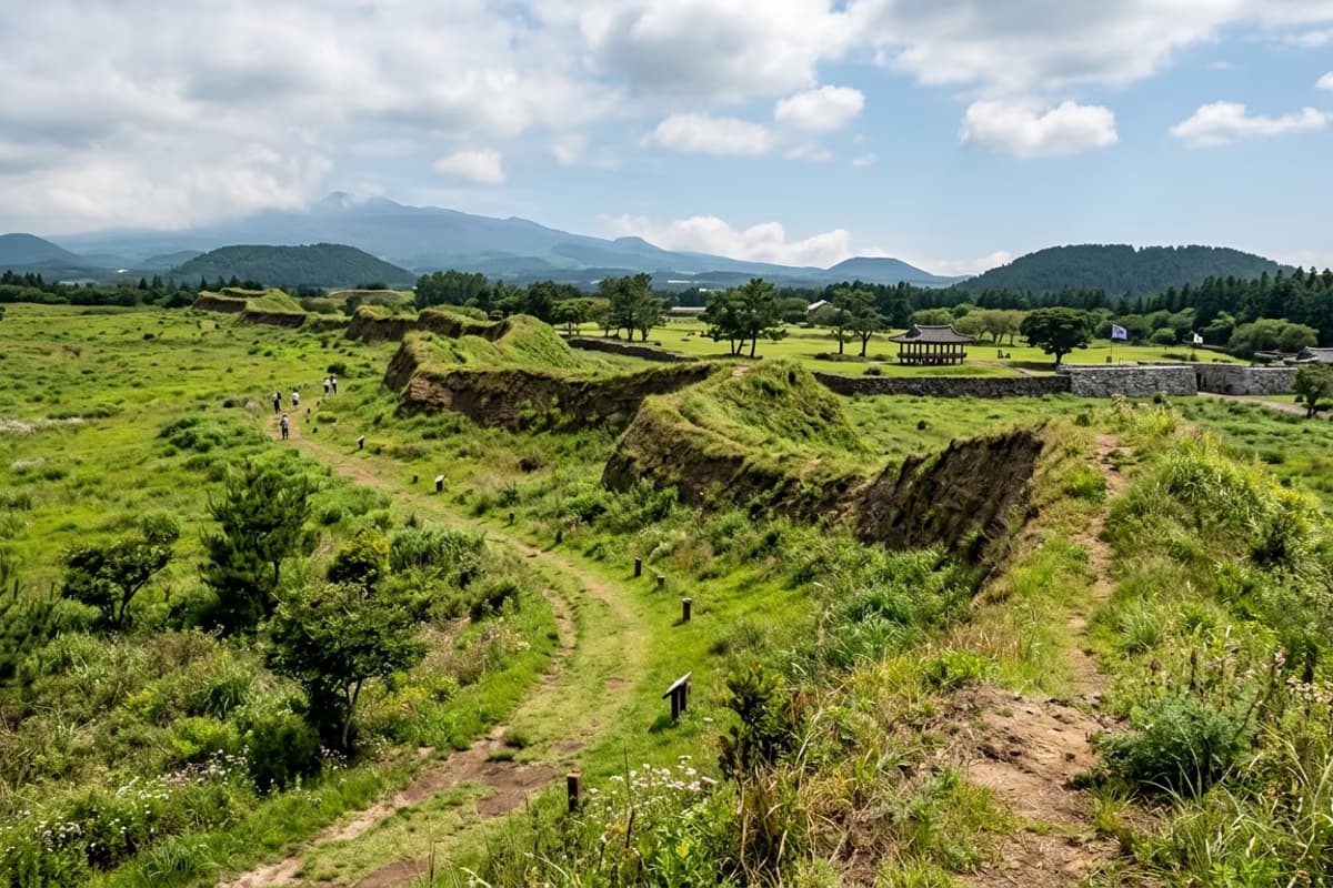
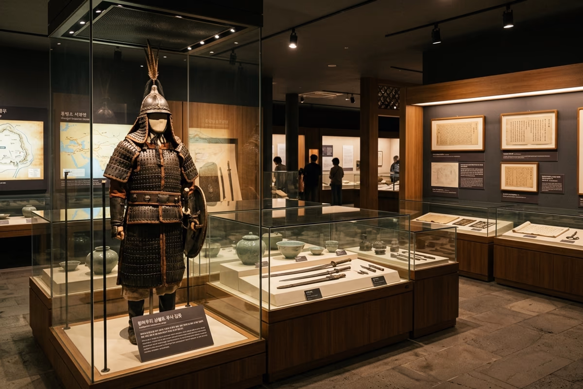
The outer wall (외성, *oeseong*) of Hangpaduri ran approximately 6 kilometers in circumference, enclosing about 1,097,490 square meters — roughly 109 hectares, comparable in area to the medieval inner city of Lübeck. Its long axis measured 1,450 meters, the short axis 660 meters. Inside was an inner citadel (내성, *naeseong*) of around 750 meters in circumference, presumed to have held the command structure and key facilities. Excavations have recovered iron armor fragments, ceramic tile shards, and arrowheads.
The construction technique was earthen rammed-wall (*toseong*) — soil and stone gathered from the immediate surroundings, layered and compacted in horizontal courses. This was not unusual for thirteenth-century East Asia; the same technique had been used at the Goryeo capital's outer wall and at sites across Song-dynasty China. What was unusual at Hangpaduri was the *speed*: an entire fortified perimeter on this scale, built in months, on an island reached by sea, by a force already cut off from its home territory. The wall trace survives today in clearly identifiable sections along the walking path. Climbing the outer wall and looking outward, the strategic logic is immediately legible: sightlines open in every direction across the mid-mountain pasture, with the sea visible to the north and Hallasan rising to the south.
The choice of mid-mountain slope rather than coastal harbor matters. A coastal site would have been faster to abandon under siege but easier for a hostile fleet to encircle. The 120-220 meter elevation gave Hangpaduri elevated defensive ground while keeping a short overland line to the coast for resupply by sea.
The Sambyeolcho: From Imperial Bodyguard to Last Resistance
The Sambyeolcho (三別抄) were originally formed in 1232 as the Goryeo military regime's elite night-watch and capital security force. Over the next four decades, as the Mongol Empire pressed harder, they evolved into the regime's spearhead — the unit that conducted raids, anti-pirate operations, and the rear-guard defense of Ganghwa Island where the court had retreated.
When the Goryeo court formally accepted Mongol terms in 1270 and returned from Ganghwa to the capital at Gaegyeong, the Sambyeolcho refused the order to disband. Under the leadership of Bae Jung-son and later Kim Tong-jeong, they relocated their forces to Jindo (an island off Korea's southwest coast) and established a counter-government. When Jindo fell to a Goryeo-Mongol assault in April 1271, the survivors — including Kim Tong-jeong — crossed by sea to Jeju.
What followed was a two-year period in which the Sambyeolcho controlled Jeju from Hangpaduri, conducted raiding operations along the Korean coastline, and held out against the assumption that the Mongol settlement was final. The strategic calculation was that Mongol power, projected at this distance, was thinner than it appeared close to the capital — a calculation that mirrored similar resistance strategies pursued at Xiangyang (a 6-year siege ending the same month Hangpaduri fell), in Vietnam under the Tran dynasty, and against the later Mongol invasions of Japan in 1274 and 1281.
In April 1273, a combined Goryeo-Mongol force of approximately 10,000 troops launched the final assault. Kim Tong-jeong was killed in the engagement. The fortress fell. With it ended the forty-year Goryeo resistance to Mongol invasion.
What You Can See and What Was Excavated
The site today preserves four primary elements:
The wall trace. Sections of the outer earthen wall survive at recognizable height, particularly along the eastern and southern arcs. A walking path follows the trace; the full perimeter takes about 1.5 hours at a moderate pace, but the recommended visit covers about 1.5 kilometers of the most legible sections (40-60 minutes).
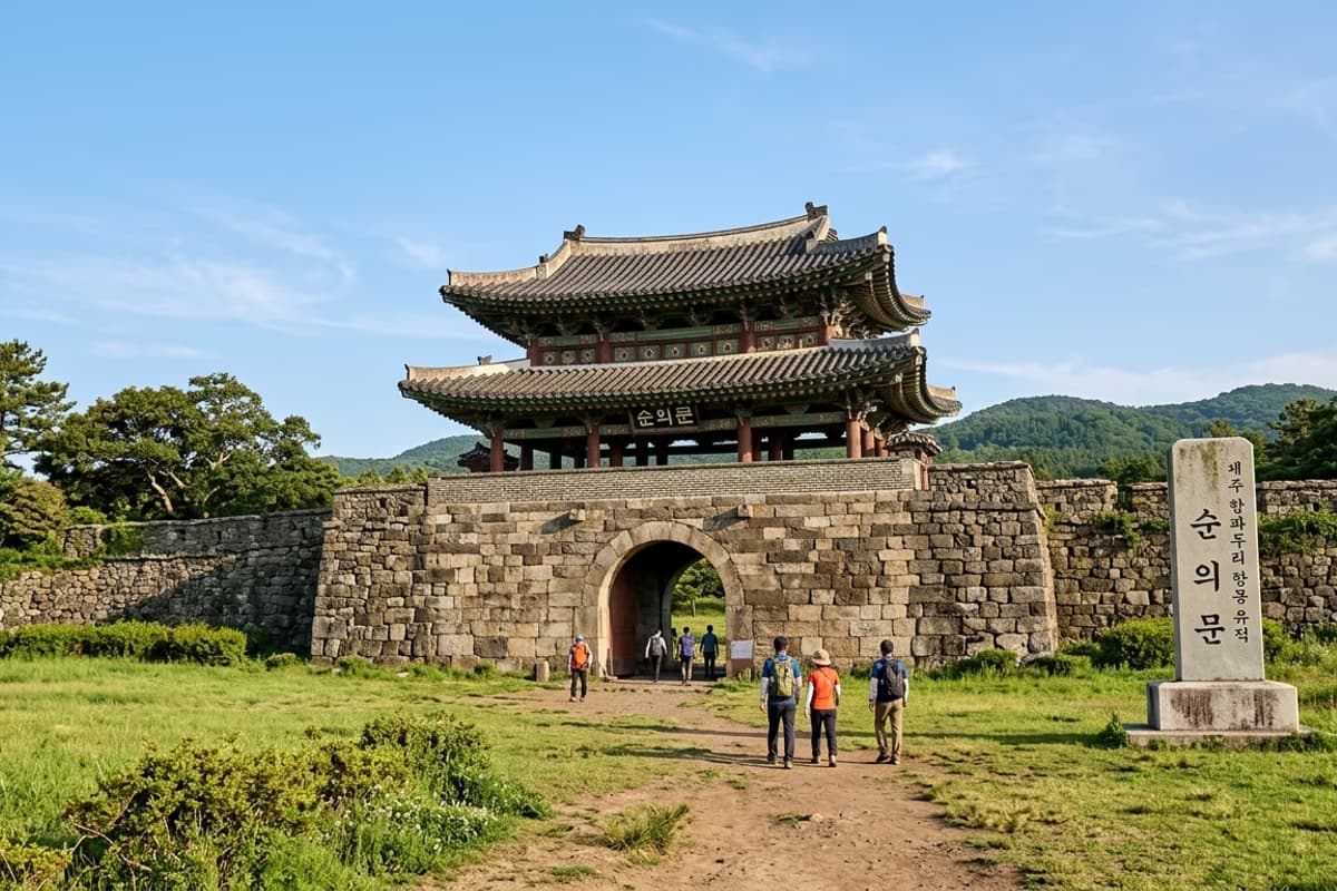
The Memorial Gate (Sunuimun) and Memorial Stele (Sunuibi). Modern additions commemorating those who died defending the fortress. The gate marks the formal site entrance.
The Exhibition Hall. Free admission. Display panels reconstruct the Sambyeolcho's route from Ganghwa to Jindo to Jeju in chronological order, and display excavated artifacts — iron armor scales, ceramic roof tile fragments, arrowheads, pottery sherds. According to the Korea Heritage Service English portal, the site was designated National Historic Site No. 396 in 1997, and is described as the earliest known example of a maritime resistance fortress against the Mongol Empire in Korean history.
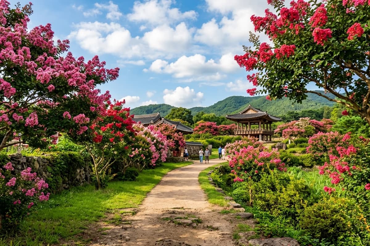
The crepe myrtle path. A surprise August bonus — the *baerongnamu* (crepe myrtle) trees planted throughout the site bloom in deep magenta for several weeks in midsummer, creating an unexpected horticultural layer over the military-history experience.
How to Combine the Site with the Surrounding Area
Hangpaduri sits in Jeju's mid-mountain belt (*jungsangan*), 120-220 meters above sea level. The surrounding landscape is grassland and grazing pasture — open sightlines, basalt stone walls, occasional horse herds in the middle distance. Walking the perimeter takes roughly the time a visitor would spend at a comparable Welsh castle or English motte-and-bailey site.
For a half-day plan:
- Morning (09:30-11:00): Hangpaduri exhibition hall + wall walk
- Midday (11:30-13:00): Lunch in the village of Napeup nearby (basic Korean rural restaurants)
- Early afternoon (13:30-15:30): Napeup Subtropical Forest → — a 33,980-square-meter natural-monument evergreen broadleaf forest, walking distance from the village
- Late afternoon onwards: descend the 15-20 minutes by car to Galchibada in Aewol for dinner facing the sea the Sambyeolcho once crossed
The pairing — a thirteenth-century military fortress and a natural-monument forest — comes from the same logic that made Hangpaduri viable in the first place: the mid-mountain belt held both defensive geography and the natural resources to sustain a force inside it.
Practical Information
Address: 50 Hangpaduri-ro, Aewol-eup, Jeju-si, Jeju Province
Hours: 09:00-18:00 (last entry 17:30), year-round
Admission: free (site, exhibition hall, parking all free)
Travel time from Jeju Airport: approximately 35 minutes by car via Pyeonghwa-ro (Route 1135)
Footwear: wall path is unpaved in sections — closed shoes recommended
Summer note: limited shade along the wall trace; bring a hat and water
Frequently Asked Questions
What is the entrance fee to Hangpaduri Anti-Mongol Site?
Free. Admission, parking, and exhibition hall are all free of charge.
How long does a typical visit take?
About 1 to 1.5 hours covers the exhibition hall, the memorial structures, and a representative section of the wall trace.
What is the historical significance of the Sambyeolcho and Hangpaduri?
The Sambyeolcho were a Goryeo military elite that refused the Mongol-imposed peace settlement of 1270. They relocated their resistance to Jindo and then to Jeju, where they built Hangpaduri Fortress in 1271 and held out until the site fell to a joint Goryeo-Mongol force in April 1273 — ending the 40-year Goryeo resistance to Mongol invasion.
How far is Hangpaduri from Galchibada in Aewol?
About 15-20 minutes by car. A typical route is fortress walk in the morning, descend to the coast for dinner.
Dinner recommendation after visiting Hangpaduri?
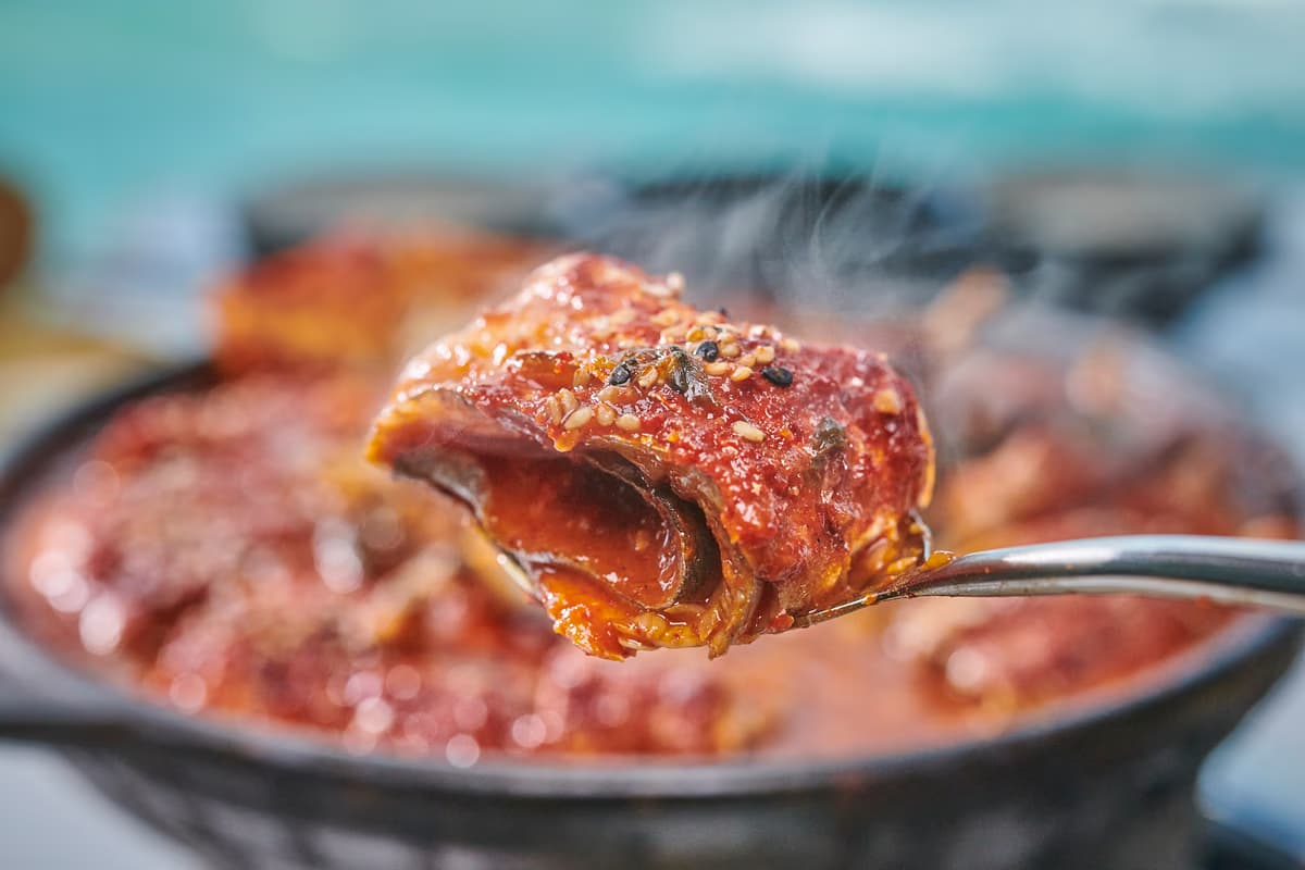
Galchibada in Aewol is the natural pairing — 15 minutes downhill on the coast, ocean-view seating, wild silver hairtail braise and grill. The descent from the mid-mountain fortress to the coastal dining room is itself part of the route the Sambyeolcho once traveled.
Frequently Asked Questions
- What is the entrance fee to Hangpaduri Anti-Mongol Site?
- Free. Admission, parking, and exhibition hall are all free of charge.
- How long does a typical visit take?
- About 1 to 1.5 hours covers the exhibition hall, the memorial structures, and a representative section of the wall trace.
- What is the historical significance of the Sambyeolcho and Hangpaduri?
- The Sambyeolcho were a Goryeo military elite that refused the Mongol-imposed peace settlement of 1270. They relocated their resistance to Jindo and then to Jeju, where they built Hangpaduri Fortress in 1271 and held out until the site fell to a joint Goryeo-Mongol force in April 1273 — ending the 40-year Goryeo resistance to Mongol invasion.
- How far is Hangpaduri from Galchibada in Aewol?
- About 15-20 minutes by car. A typical route is fortress walk in the morning, descend to the coast for dinner.
- Dinner recommendation after visiting Hangpaduri?
- Galchibada in Aewol is the natural pairing — 15 minutes downhill on the coast, ocean-view seating, wild silver hairtail braise and grill. The descent from the mid-mountain fortress to the coastal dining room is itself part of the route the Sambyeolcho once traveled.
Setting down 750 years of history at a coastal dinner table
From a thirteenth-century wall to a tender hairtail fillet by the sea
The sea visible from the top of the Hangpaduri wall is the same sea the Sambyeolcho crossed by sail in 1271 — but on tonight's window seat, fifteen minutes downhill, that water has nothing to do with siege logistics. A tender fillet of wild silver hairtail melts on the tongue with the kind of softness only available to those for whom thirteenth-century war is a museum subject. The descent itself — fortress to coastline, war to peace, then to now — turns out to be part of what the site teaches.
15 minutes downhill from the fortress to Galchibada in Aewol →