Napeup Subtropical Forest — 750-Year Sanctuary, Jeju Aewol
One of the Last Lowland Old-Growth Patches in Korea — Walking the 8.4-Acre Canopy in Aewol
Napeup Subtropical Forest (Natural Monument No. 375, designated 1993) is a 33,980-square-meter (~8.4-acre) evergreen broadleaf forest in Aewol-eup, Jeju — the last remaining patch of lowland old-growth forest on Jeju's western coastal plain. The community of Napeup-ri protected it as geumsan ("forbidden mountain") for over 750 years, a vernacular conservation tradition parallel to England's Royal Forests or Vermont's town forests. Around 60 subtropical plant species form a multilayered canopy. The loop trail takes 30-40 minutes at an easy pace. Free admission, open year-round. Galchibada in Aewol is 10-15 minutes by car.
When most travelers picture Jeju, they picture the ocean. The volcanic coast, the black-sand beaches, the silver hairtail at dinner. But there is another Jeju, much older and much quieter, that hides on the mid-mountain slope ten minutes inland from Aewol's coffee road: a 33,980-square-meter (~8.4-acre) patch of evergreen broadleaf forest that the village of Napeup has been protecting, by collective village ordinance, since the late thirteenth century.
This piece is for travelers who plan trips around forests rather than around restaurants — readers who would route a vacation through Muir Woods, the Olympic Peninsula's temperate rainforest, the Forest of Dean in Gloucestershire, or Białowieża on the Polish-Belarusian border. Napeup belongs in that conversation. It is not large — the entire site is closer in scale to a Vermont town forest than to a national park — but the *conservation logic* that produced it has direct parallels in those other places. The forest survived because a single rural community drew a line around it and held that line for three quarters of a millennium.
A Lowland Old-Growth Patch That Should Not Still Exist
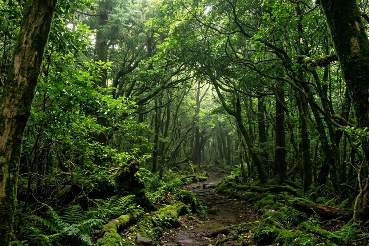
Most of Jeju's coastal lowland was once covered in evergreen broadleaf forest — the same vegetation type that survives in southern Japan, southern China, and Taiwan's lower elevations. Centuries of agricultural clearance, basalt-wall pasture conversion, and twentieth-century development reduced it to scattered fragments. Napeup Subtropical Forest is the largest and best-preserved fragment that remains at low elevation on the island's western half. According to the Korea Heritage Service English portal, the site was designated Natural Monument No. 375 in 1993 specifically for this rarity — a near-intact ecosystem of roughly 60 subtropical species inside a landscape otherwise reshaped by human use.
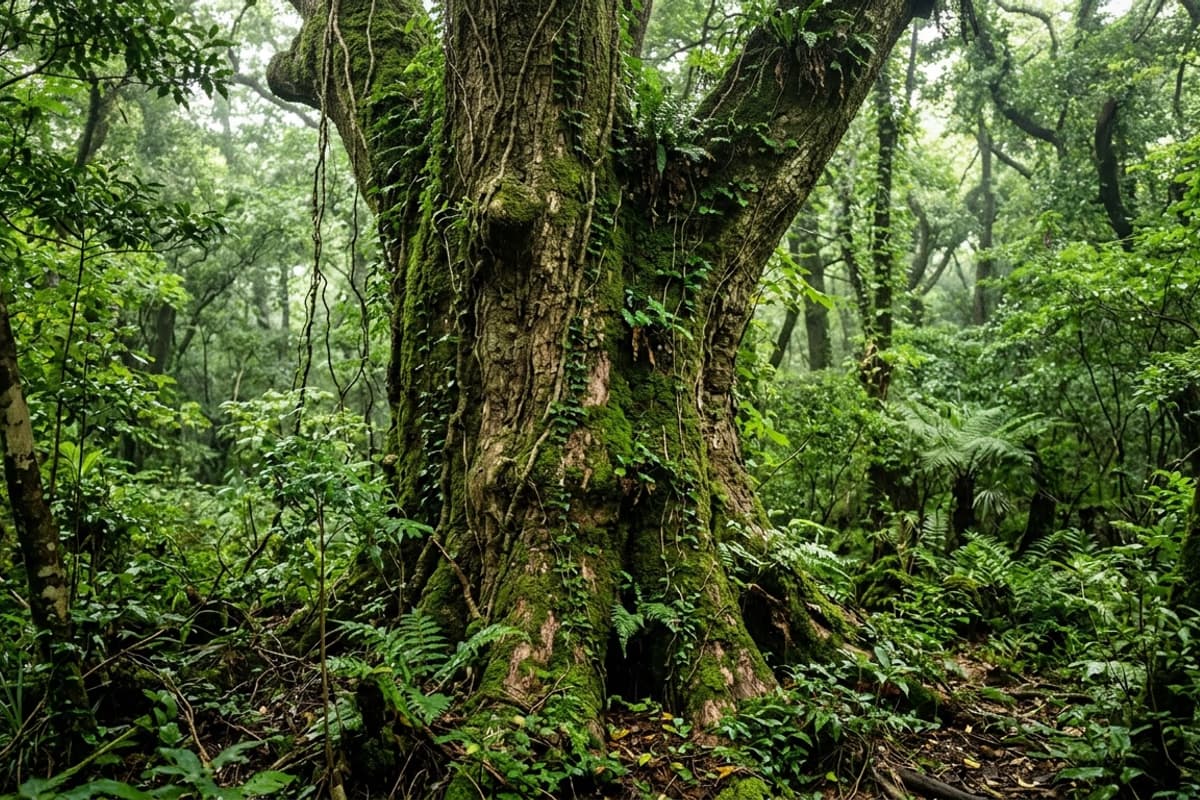
The dominant canopy trees are *Machilus thunbergii* (Japanese bay tree, locally called *hubaknamu*) and *Quercus glauca* (ring-cupped oak, *jonggashinamu*). Below them, an understory of *Neolitsea sericea* (silky-haired Chinese laurel, *saengdalnamu*) and *Ardisia japonica* (Japanese coralberry, *jageumu*) holds the shade. Vines — *Trachelospermum asiaticum* (Asian jasmine, *masakjul*) and *Hedera rhombea* (Japanese ivy, *songak*) — climb the trunks and cross the upper canopy, knitting the whole forest into something that reads like a single living organism. Visitors familiar with the laurel-leaf forests of southern Honshu or the lower evergreens of Taiwan's Fushan Botanical Garden will recognize the structural pattern immediately.
The Geumsan Tradition — A 750-Year Village Compact
The forest survived because the people of Napeup-ri designated it *geumsan* (禁山) — literally, "forbidden mountain" — and enforced that designation collectively across generations. The village treated the forest as a windbreak shielding the settlement from north-westerly storms, as a sacred grove with ritual significance, and as a communal asset whose value depended on remaining intact. Logging, cultivation, and game hunting were proscribed by village consensus, not by royal decree.
This is what makes Napeup historically interesting beyond its botany. The parallel that comes most naturally to English-language readers is the *commons* tradition — the medieval English practice of jointly managed grazing and forest land, which Garrett Hardin's 1968 essay famously (and contentiously) discussed as "the tragedy of the commons." Elinor Ostrom's later Nobel-recognized work demonstrated that well-managed commons, governed by clear local rules, did *not* collapse. Napeup-ri's geumsan is a textbook Ostromian case: stable boundaries, locally legitimate rules, monitoring by community members, and continuous transmission of management norms across at least twenty-five generations.
Since 1993, the Korean state has assumed legal protection through the Cultural Heritage Protection Act, which prohibits all forms of harvest, collection, and disturbance. Visitors stay on the trail and do not touch the plants — the standard etiquette anywhere a community has protected something for this long.
Walking the Loop — Sensory Notes
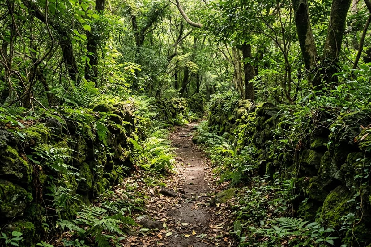
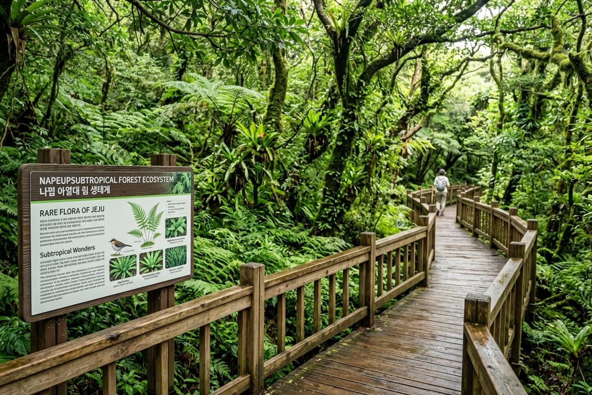
A graded loop trail runs the full perimeter of the protected area. At an easy pace, the circuit takes 30 to 40 minutes. The trail is flat and well maintained, suitable for ordinary walking shoes; no equipment is needed beyond what a visitor would carry to a city park. Interpretive signs along the way identify dominant species and explain canopy structure.
What changes inside the forest is not the visual experience — though the filtered green light is striking — but the *acoustic and olfactory* register. Sound from the surrounding roads drops away within ten paces of the entrance. The smell shifts: humid leaf litter, the faintly sweet evergreen note of *Machilus* foliage, the cool damp of moss-covered basalt walls. Visitors who arrive after a morning of bright coastal sightseeing often describe the entrance to the forest as a sensory reset — the visual saturation of the sea giving way to a much narrower, much deeper sensory band inside the trees.
Restrooms are at the entrance. There is no concession stand inside the forest; bring water. Even in light rain the canopy intercepts most precipitation, but the unpaved sections become slippery, and closed shoes are recommended in any season.
Pairing the Forest With the Surrounding Area

Napeup sits in Jeju's *jungsangan* (mid-mountain) belt at elevations roughly 200-300 meters above sea level — the same elevation band that produced the strategic logic of the nearby Hangpaduri Anti-Mongol Fortress →, ten minutes away by car. The fortress and the forest are products of the same geographical layer: high enough to be defensible and ecologically distinct, low enough to remain accessible to the coastal settlements below.
A natural half-day plan reads:
- Morning (09:30-11:00): Hangpaduri exhibition hall + earthen-wall walk
- Late morning (11:15-12:30): drive 10 minutes to Napeup, loop the forest
- Lunch (12:45-14:00): village restaurants in Napeup or along the coastal road
- Afternoon onwards: descend 10-15 minutes to the Aewol coast — coffee-road cafes, Handam coastal walk, sunset over Biyangdo island visible from the western beaches
- Evening: dinner at Galchibada in Aewol facing the same coastline the Napeup villagers were buffering from northerly storms for seven centuries
The pairing — a thirteenth-century military fortress and an evergreen forest preserved by the same era's village ordinance — is not a coincidence of itinerary planning. Both belong to the same historical geography of Jeju's mid-mountain belt. Reading them in sequence reveals a layer of the island that pure-coast tourism does not access.
Practical Information
Address: Napeup-ri, Aewol-eup, Jeju-si, Jeju Province
Hours: open year-round, no posted closing time (daylight hours recommended)
Admission: free
Travel time from Jeju Airport: approximately 25 minutes by car via Pyeonghwa-ro (Route 1135)
Trail length: roughly 1 km loop, 30-40 minutes at an easy pace
Surface: graded earthen path, mostly flat — closed shoes recommended
Best months for visiting: late April through October. Peak canopy density in mid-summer; understory at its richest after the July monsoon
Accessibility: trail is mostly flat but unpaved — partially passable for assisted mobility but not fully wheelchair-accessible end-to-end
The walk out of the forest, back into the bright Jeju coastal afternoon, is part of the experience. Carrying the cool damp of the canopy down the ten-minute road to Galchibada in Aewol, settling into a window table facing the same west coast Napeup villagers were buffering from northerly storms for seven centuries — the contrast becomes the point. The forest's gift is to slow down the senses; the ocean afterwards turns out to be more vivid because of it.
Frequently Asked Questions
- How much does it cost to visit and when is it open?
- Admission is free. The site is open year-round with no posted closing time, but daylight hours (roughly 09:00-17:30 depending on season) are recommended. The full loop trail takes 30-40 minutes at an easy pace.
- When is the best season to visit Napeup Subtropical Forest?
- Late April through October. Canopy density peaks in mid-summer (July-August), and the understory ferns and ground-layer plants are at their richest after the monsoon. November to March is also walkable, though the contrast with the surrounding deciduous landscape is less dramatic.
- Is the trail wheelchair-accessible?
- The trail is mostly flat but unpaved (a graded earthen path). The first 100-200 meters are partially passable for assisted mobility, but the full loop is not fully wheelchair-accessible end-to-end. Closed shoes are recommended for all visitors.
- Can I take photographs inside the forest?
- Personal photography is permitted. Commercial photography and drone use require advance permission from the Cultural Heritage Administration. Stepping off the marked trail is prohibited under Natural Monument protection regulations.
- How does Napeup compare to Jeju's other famous forests like Saryeoni?
- Saryeoni Forest is a planted Japanese cedar (Cryptomeria) forest at higher elevation (around 600 meters), established in the mid-twentieth century. Napeup is an old-growth evergreen broadleaf forest at low elevation, preserved by village ordinance for over 750 years. The two are complementary rather than comparable — Saryeoni for the dense conifer atmosphere, Napeup for the rare lowland subtropical ecology.
An afternoon table that still holds the forest's stillness
From the quiet of an old-growth canopy to a window table facing the sea
Step back out from beneath the cool damp of the canopy, drive ten minutes downhill to the coast, and the dimness of the forest gives way to a clear horizon. A window seat where the afternoon light pours through floor-to-ceiling glass — the slowness the forest just gave you carries straight through into the meal. A braised hairtail tasted with senses freshly tuned by an old-growth forest is not the same dish as one tasted on a normal afternoon.
10 minutes from the forest · floor-to-ceiling ocean view, hairtail specialty →