Jeju Olle Trail Course 16 — A 15-km West Coast Walk
From Gonae-ri to Gwangryeong-ri on Foot, with One of the Few Olle Routes That Actually Puts Lunch on the Line
Olle Trail Course 16 runs about 15.8 km / 9.8 miles from Gonae Port (Gonae-ri) to the Gwangryeong-ri transfer stop, walking time 5 to 6 hours plus a sit-down lunch. The headline section is the Handam coastal walkway, where basalt cliffs and emerald water sit so close you can read the bubbles in the lava. Aewol Port at the midpoint is the natural lunch stop — Galchibada Aewol is a 10-minute walk from the dock. Free trail. Trekking poles optional. The official map is downloadable from the Jeju Olle Foundation.
If you have walked even a few stages of the Camino de Santiago, the Jeju Olle network is going to feel uncannily familiar. Same hand-painted arrows, same ribbon trail markers, same quiet conspiracy between walkers who pass each other on a country lane. The reason is not a coincidence — founder Suh Myung-Sook walked the Camino in 2007, took the idea home, and the first Olle stage opened the same year. Of the 26 routes that now make up roughly 437 km of trail around the island, <strong>Course 16</strong> threads the west coast between Gonae-ri and Gwangryeong-ri for 15.8 km (9.8 miles), and it remains one of the few stages where lunch actually lands on the trail itself.
The headline distance is well within range for a Western walker who has done a Camino day or a Cotswold Way segment — five to six hours of walking time plus a deliberate sit-down lunch. What sets it apart is the rhythm: basalt shoreline, then a fishing port, then a 1.2 km headland of emerald water at the Handam walkway, then mid-mountain hamlets where the only sound is silver grass against your sleeve.
The Course Broken into Three Honest Segments
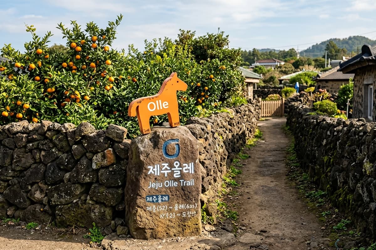
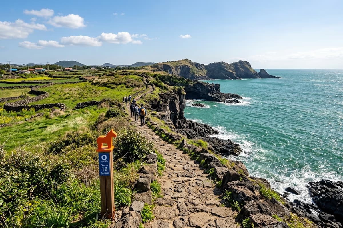
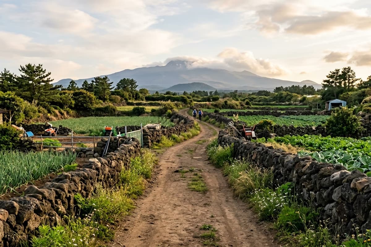
The official start is at Gonae Port, where the first Ganse marker — a small wooden pony, the Olle network's mascot — points you west. The route splits naturally into three honest segments.
The first 5 km (3.1 miles) runs Gonae-ri → Aewol Port — basalt foreshore alternating with village lanes, around 90 minutes. The second 5 km (3.1 miles) runs Aewol Port → Gwakji Beach, which is the postcard segment — the Handam coastal walkway sits inside it — also 90 minutes. The final 5.8 km (3.6 miles) Gwakji → Gwangryeong-ri climbs gently into the mid-mountain hamlets and takes about two hours.
Total walking time clocks in at 5 to 6 hours; budget seven if you eat properly and stop to photograph the basalt. The Jeju Olle Foundation publishes a downloadable PDF map and a GPS track for every course.
Blue Ganse arrows mean forward direction, orange means reverse. Ribbon markers fill in every junction at 100 to 200 m intervals, and emergency boards with the nearest bus stop and a hotline number show up every 1 to 2 km. Take a phone screenshot of the map at the start — that's essentially all the gear you need above what you would bring on a Cornish coastal walk. From November on, sunset drops fast enough that the visibility along the final hamlets gets thin after 4:30 p.m.; in deep winter, push your start to 8 a.m. or earlier.
Headline Section — The Handam Coastal Walkway
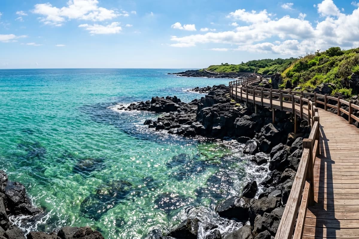
Of all 26 Olle stages, the Handam walkway is where the trail comes closest to the water — closer than it has any right to. About 1.2 km (0.75 miles) of basalt clifftop, with emerald water dropping straight down on your left and nothing between you and the open horizon. If you have stood at Land's End or on the Cinque Terre, the geological vocabulary is similar, but the colour palette is genuinely its own.
The basalt under your feet here is roughly <strong>10,000-year-old pillow lava</strong> — flows from one of Hallasan's eastern volcanic episodes that hit the sea, chilled fast, and left tortoise-shell cracks and round vent bubbles preserved exactly where they froze. Geology hiking clubs come here on weekday mornings. At low tide, small tidepools open between the rocks, where periwinkles and crabs make this a perfectly useful introduction to marine biology for any kid who came along.
The signposted "spring water" stone about halfway across the walkway is the unofficial photo composition. The bay sits open to the west, so afternoon light fills the water without backlight, and the very last hour before sunset glows the basalt orange. You will leave with more photos than you intended.
Mid-Trail Lunch — The Honest Reason to Walk Course 16
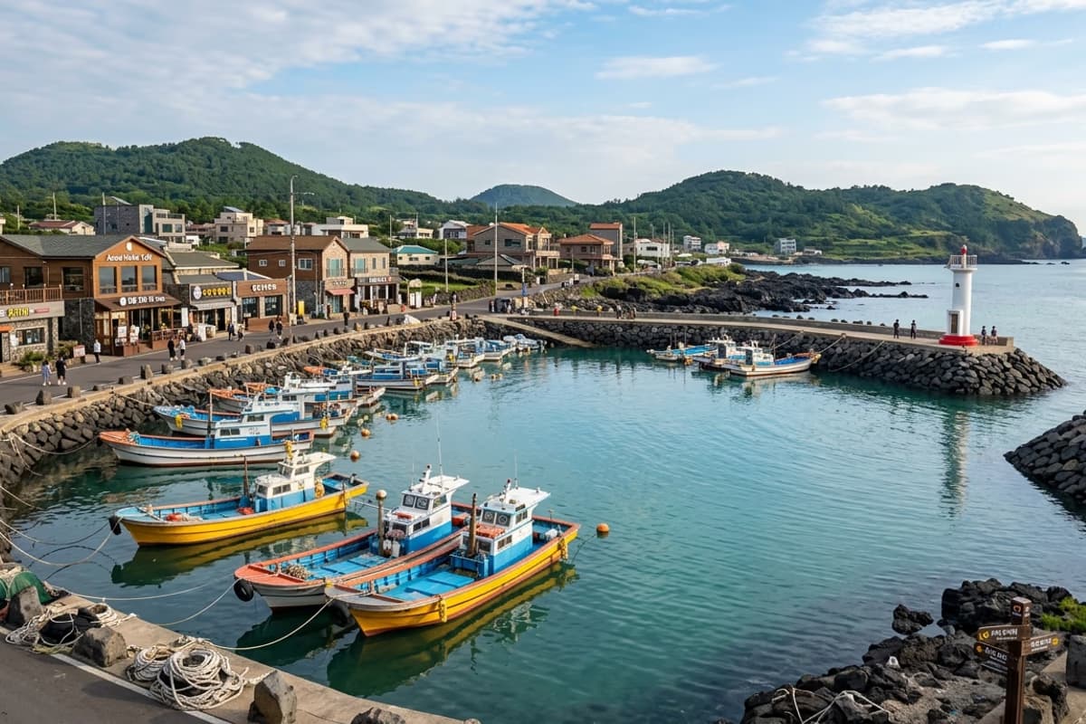
This is where Course 16 separates itself from every other Olle stage. The exact midpoint sits in Aewol Port, where you arrive around the 2.5 to 3-hour mark — which is to say, right on lunch. The fishing harbour holds a cluster of restaurants and cafés in the lanes immediately behind the dock, and walking up out of the port, hairtail (cutlassfish), jariodom (damselfish), and hanchi (Jeju longarm squid) are the canonical west-coast plates. <strong>Galchibada Aewol</strong> sits about 10 minutes on foot from the harbour and is the venue most Course 16 walkers use as their lunch pin.
The order matters: the second half's headline section — the Handam walkway — starts almost immediately after lunch, so you walk back into the most photogenic stretch of the entire route with the meal still warm. The Olle Foundation does not formally publish this fact, but everyone who has walked the course twice knows it.
Aewol Port was originally a Joseon-era military mooring; today it is a working fish-auction harbour that pulses hardest around 6 a.m. By noon, the morning catch has already scattered into the restaurants up the lane, and the port itself goes quiet enough to photograph without crowds. The lanes behind hold 1980s-era slate-roof shops with hand-painted signs still in place — a layer of time that the newer café streets along the west coast have not erased.
Crossing the Finish Line
The terminus is the Gwangryeong-ri transfer stop. From here, intercity buses 281 and 282 run back to Jeju City every 20–30 minutes, with the last departure around 9:30 p.m. and a single transfer that lands at Jeju International Airport. If you parked at Gonae Port, the cleanest move is to swap a phone number with a local taxi driver at the start, then call them when you reach the finish — local cab call times average under 10 minutes.
After 15 km, the back of the legs has an honest opinion. There's a small village park near Gwangryeong Elementary School where finishers stretch out, and two cafés with massage chairs within a 5-minute walk that handle the immediate decompression. For an easier second day in the same region, the Handam coastal walk → (the same headland you crossed mid-route) or Gwakji Beach → are gentle enough on the knees to repeat without complaint, and either one slots back into the half-day rhythm that this western coast does best — a sequel that requires nothing more than a fresh pair of socks.
Season-wise, small adjustments to the start hour change the trail completely. Spring (March–May) — leave at 8 a.m. for canola yellow leaking over village walls. Summer (June–August) — leave at 6 a.m. to dodge the midday UV, and use the air-conditioned shops at the midpoint for a strategic ten minutes. Autumn (September–November) — a 9 a.m. start lines up your finish with sunset across the silver grass. Winter (December–February) — camellia and narcissus in village gardens make for the deepest colour, but cold-snap advisories can ice the exposed cliff section, so check the Korea Meteorological Administration alerts the night before.
For walkers managing a knee or a recent injury, the course splits cleanly into two days: Gonae Port → Aewol Port one day with lunch as the natural endpoint, Aewol Port → Gwangryeong-ri the next. This halves the impact load on the joints and turns Course 16 into a comfortable two-day coastal pilgrimage rather than a single long push.
Frequently Asked Questions
- How long does the full Course 16 take?
- About 15.8 km / 9.8 miles, 5 to 6 hours of walking at a steady pace. With a sit-down lunch and photo stops, budget 7 hours. Western walkers used to a Camino day stage will find the distance moderate; the surface is mostly flat coastal trail with a gentle mid-mountain climb at the end.
- Can I walk just half of Course 16?
- Yes — and many do. The most popular half-route is Gonae-ri to Aewol Port, about 5 km / 90 minutes, which puts you at lunch in the harbour. Alternatively, starting at Aewol Port and walking to Gwakji Beach covers the Handam coastal walkway — the headline 1.2 km cliff section — in another 90 minutes.
- Is there food and water along Course 16?
- Yes, concentrated at the midpoint — Aewol Port has restaurants, cafés, and convenience stores in the lanes behind the dock. Gwakji Beach has a smaller cluster of casual eateries. The first and final segments are quieter; carry at least 1 litre of water per person, more in summer.
- How do I get back to my car after finishing at Gwangryeong-ri?
- Easiest method: swap a phone number with a Gonae Port taxi driver at the start, then call when you finish — average pickup time is under 10 minutes. Alternatively, bus 281 or 282 back to Jeju City, then a separate ride or taxi to Gonae. The buses run every 20–30 minutes, last departure around 9:30 p.m.
Mid-trail at Aewol Port — 10 minutes on foot to the hairtail table
Half the trail behind, the headline section ahead — lunch goes in the middle
When the Ganse markers have led you into Aewol Port and the next basalt cliff section is still ten minutes ahead, the cleanest stop on the entire 15 km route sits ten minutes on foot from the dock. One braised hairtail and a bowl of totbap rice — fuel measured in west-coast portions — and the second half of Course 16 is already a different walk.
10 minutes on foot from the Course 16 midpoint at Aewol Port to Galchibada Aewol →